| Ardnamurchan
Tower light: | ||
| M096 A4082 114-4016 |
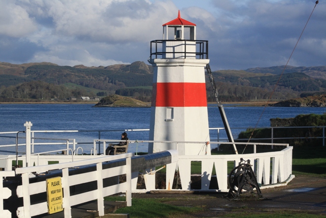
Ardnamurchan Point 2/20, 55m, 22 miles (reduced from 24 miles since 2013) NM416674 |
 Established 1849 (Alan Stevenson) Established 1849 (Alan Stevenson) Grey granite tower 36m Visible 217° through E to 002° LR47; EX390; CH (small-scale) 4102, 2, 2635, 1796, (medium-scale) 2171, 2207, 2392 Access on foot from car park: tower sometimes open |
Kilchoan Onastic light: | ||
| M096-01 A4109 114-4030 |
Mingary Pier Head QR, 8m, 3 miles NM493627 |
Grey post image detail image LR47; EX390; CH (medium-scale) 2171, 2392 |
Loch Aline The sand mine at Loch Aline closed in 2008, and was re-opened under new owners in 2012. The associated lights had been refurbished and are listed here as M096-05 to 07: -05 replaces -02, -06 replaces -03 and -04, -07 is new. Onastic lights: | ||
| M096-02 A4125 114-4042 |
Pier 2FR, 4m, 3 miles NM680447 replaced 2012 by M096-05 |
Post image LR49; EX383 Access along pier |
| M096-03 A4125·3 114-4043 |
Ldg lts front FW, 2m, ? miles NM680451 Discontinued 2008 |
Decaying column image LR49; EX383 At roadside |
| Wall-mounted light: | ||
| M096-04 A4125·31 114- 4043.1 |
Ldg lts rear FW, 4m, ? miles NM680452 Discontinued 2008 |
Lantern in niche in industrial building image LR49; EX383; CH2171, 2390 No access |
| Onastic lights: | ||
| M096-05 A4125 114-4042 |
Pier 2FR, 4m, 3 miles NM680447 |
Post image LR49; EX383; CH (medium-scale) 2171, 2390, (small-scale) 2390·2 Access along pier |
| M096-06 A4125·3 114-0 |
Directional light WRG Oc/6, 2m, 4/4/4 miles NM680451 Established 2012 |
Orange concrete column 2m images Sectors: 002° R 358° W 356° G 353° LR49; EX383; CH (medium-scale) 2171, 2390, (small-scale) 2390·2 On beach at roadside |
| M096-07 A4125·4 114-0 |
R 1/4, 3m, 2 miles NM Established 2012 |
Post on end of pontoon image LR49; EX383; CH (medium-scale) 2390, (small-scale) 2390·2 No access |
| Tower light: | ||
|
M097 A4124 114-4040 |
Ardtornish Point WRG 2/10, 8m, 8/6/6 miles NM692425 |
 Framework tower with white cladding Framework tower with white cladding on concrete base with railing 5m Sectors: shore G 108° W 095° R 057° W 342° R 308° W (6°) 302° G 185° LR49; EX375, 383; CH (medium-scale) 2171, 2390 Access by boat, or about 5 miles down private road followed by half a mile over rough country |
Glensanda (no access) Onastic lights: | ||
| M097-01 A4151 114-4095 |
Breakwater Head 2FR, 5m, 3 miles NM827471 |
Grey post 3m no image available LR49; EX376, ?383; CH (medium-scale) 2389, (large-scale) 2389·1 |
| M097-02 A4150 114-4093 |
Jetty SW corner R 1/3, 5m, 4 miles NM830474 |
Grey post 2m no image available LR49; EX376, ?383; CH (Medium-scale) 2171, 2389, (large-scale) 2389·1 |
| M097-03 A4150·2 114-4094 |
Jetty NE corner R 1/3, 5m, 4 miles NM831475 |
Grey post 2m no image available LR49; EX376, ?383; CH (medium-scale) 2171, 2389, (large-scale) 2389·1 |
Loch Linnhe narrows, west side Tower light: | ||
|
M098 A4132 114-4080 |
Corran Ferry WRG Iso/4, 12m, 10/7/7 miles NN017635 Called by the Admiralty Corran Point, but this leads to confusion with M106-07 in West Loch Tarbert |
 White tower 13m White tower 13mSectors: 069° R 030° W (10°) 020° G 215° W 195° R 132° LR41; EX384, 391; CH (medium-scale) 2379, 2380, (large-scale) 2372A At roadside |
| Onastic light: | ||
| M098-01 A4132·4 114-4082 |
Corran R 1/5, 7m, 3 miles NN016637 |
Grey lighting standard 8m image LR41; EX384, 391; CH (medium-scale) 2379, 2380, (small-scale) 2372A On dolphin |
Corpach Harbour Onastic lights: | ||
| M098-02 -- -- |
Obstruction marker FOr, ?, ? miles NN088765 |
White board on pile 8m image LR41; EX384, 391; not charted or listed by Admiralty No access |
| M098-03 -- -- |
Quay, SW corner G 1/5, 0m, 3 miles NN088765 |
Lantern mounted directly on ground, maybe 4 inches high image LR41; EX384, 391; not charted or listed by Admiralty Access across industrial ground |
The post at the SE corner of the quay, listed as A4141 with 2FG, does not seem to exist. No such lights are visible at night. The Admiralty also lists A4141·1, Eilean na Craobh Pier, with R 2/6, but Michel has not yet seen it on the chart. | ||
Caledonian Canal As presaged in Section E, Michael lists the lights south of Loch Ness here. The Corpach light is on the west bank. The other two are on the east bank, and to maintain geographical order, Fort Augustus is listed first Tower lights: | ||
|
M099 A4140 114-4092 |
Corpach WRG Iso/4, 6m, 5 miles NN095767 |
 White tower with black conical top 6m White tower with black conical top 6m
Sectors: 030° R 335° W 310° G 287° LR41; EX392, 399; CH (medium-scale) 1791A, 2380, (large-scale) 2372B Access on foot past canal offices from station car park |
|
M100 A3472 114-0 |
Fort Augustus G 1/3, 9m, 4 miles NH382093 |
 White tower with black conical top 6m White tower with black conical top 6m
Visible 202° G 265° LR34; EX400; CH (medium-scale)1791A, 1791B, 1791F No access, but easily visible from car park at end of road past Inveroich House |
|
M101 A3480 114-0 |
Gairlochy WG 1/3, 7m, 4 miles NN182846 Not shown in summer |
 Present tower built 1932 Present tower built 1932White tower with black conical top 6m in older lists called Mucomir, after a farm nearby Sectors 260° G 245° W 180° LR34, 41; EX400; CH (medium-scale) 1791A, 1791C Access on foot along canal tow-path from Gairlochy |
|
Loch Linnhe narrows, east side Tower light: | ||
| M102 A4133 114-4084 |
Narrows NE 1/5, 4m, 4 miles NN024641 |
 Framework
tower with white GRP cladding 4m Framework
tower with white GRP cladding 4mLantern on short black post on top, partly hidden by railings Established in this form November 2009 Visible 214° through 090° to 002° LR41; EX384, 391; CH (medium-scale) 2380, (small-scale) 2372A Access by struggling through dense wood from roadside |
Appin Tower light: | ||
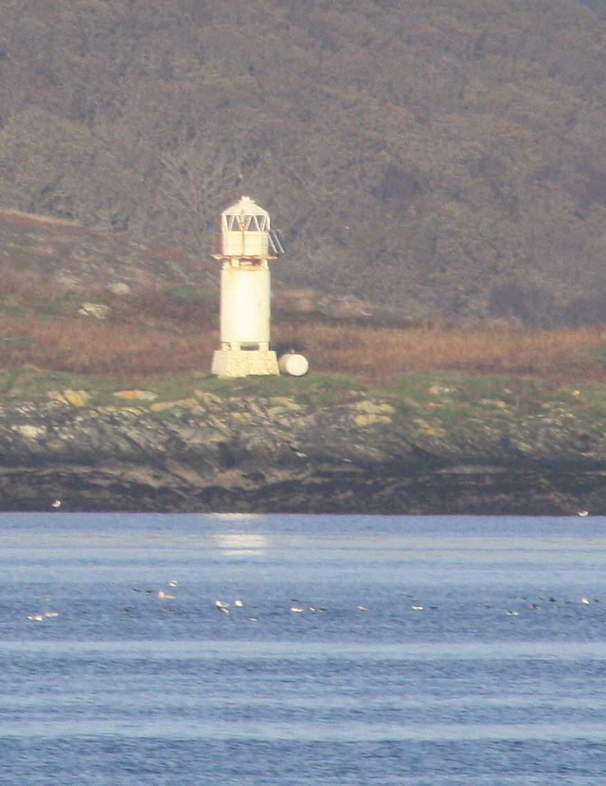
|
M103 A4160 114-4076 |
Sgeir Buidhe WR 2/7, 8m, 9/6 miles NM905462 |
 Established 1904 (David A. Stevenson) Established 1904 (David A. Stevenson)(rebuilt 2002) White cast-iron tower with balcony on concrete base with railings 8m Sectors: 220° R 184° W 013·5° LR49; EX376; CH (medium-scale) 2379, 2388 Access by boat only |
| Onastic lights: | ||
| M103-01 A4164 114-4060 |
Airds Point (Dearg Sgeir) WRG 1/2, 2m, 3/1/1 miles NM898436 |
Red post Sectors: 196° R 246° W 258° G 041° W 058° R 093° W 139° image LR49; EX376; CH (medium-scale) 2379, 2388 Access by boat only |
| M103-02 A4163 114-0 |
Branra Rock 2/10, 3m, 5 miles NM883433 |
Established 2011 on existing unlit beacon White metal column with railed platform 4m image LR49; EX376; CH (medium-scale) 2379, 2388 Access by boat only |
| M103-03 A4165 114-4064 |
Eriska NE Point (Rubha nam Faoileann) QG, 2m, 2 miles NM909435 |
Green post Visible 329° G through 180° to 128° image LR49; EX376; CH (medium-scale) 2379 Access across private ground (ask at the hotel) |
The lights at the south end of the island of Lismore are listed with Mull in Section U Connel Bridge Girder-mounted lights: | ||
| M103-04 A4175·8 114-0 |
S tower E side FR, 16m, 2 miles NM912344 |
image LR49; EX359, 376; CH (medium-scale) 2388, (large-scale) 2388B No access |
| M103-05 A4175·81 114-0 |
S tower W side FR, 16m, 2 miles NM911344 |
image LR49; EX359, 376; CH (medium-scale) 2388, (large-scale) 2388B No access |
Dunstaffnage The three lights A4175·1, A4175·2 and A4175·5 proposed in 2006 have now (2012) been officially abandoned and removed from the Admiralty's list. A light has been established on the breakwater. The four following onastic lights have been renumbered. Onastic lights: | ||
| M103-06 A4175·5 114-0 |
Breakwater head 2FG, 3m, 1 mile NM |
Pontoon no image available LR49; EX359, 376; (not charted) Access on foot |
| M103-07 (was -06) A4175·4 114-4096 |
Pier head 2FG, 4m, 2 miles NM883343 |
Pontoon image LR49; EX359, 376; CH (medium-scale) 2388, (small-scale) 2388B Access on foot |
Lights on Kerrera and in the Sound are best seen from the mainland and are therefore included in this Section Kerrera North end Onastic lights: | ||
| M103-08 (was -07) A4176 114-4100 |
North Spit R 1/3, 9m, 5 miles NM847313 |
White concrete column, red bands 10m image LR49; EX359, 376; CH (medium-scale)(2171), 2387, 2388, 2389, (large-scale) 1790 Access on foot across drying rocks |
| M103-09 (was -08) A4179 114-4105 |
Rubh' a' Chruidh QR, 3m, 4 miles NM849310 |
White post with railed platform and ladder 3m images LR49; EX359, 376; CH (medium-scale) 2387, (2388), 2389, (large-scale) 1790 Access on foot across drying rocks |
|
Oban Tower light: | ||
|
M104 A4178 114-4104 |
Dunollie WRG 2/6, 7m, 8/6//6 miles NM852311 |
 Stone tower with white lantern; Stone tower with white lantern;balcony and external ladder 6m Sectors: 143° G (5°) 138° W 120° R 047° W 020° G 351° LR49; EX359, 376; CH (medium-scale) 2171, 2387, 2388, 2389, (large-scale) 1790 At roadside |
| New lights and discontinuations in Oban Harbour have
necessitated some renumbering Onastic lights: | ||
| M104-01 A4180 114-4108 |
North Pier 2FG, 8m, 4 miles NM857301 Range reduced after 2012 |
Post 6m image LR49; EX359, 376; CH (medium-scale) (2387), (2389), (large-scale) 1790 At roadside |
| The following light is new since 2012 | ||
| M104-02 A4180·5 114-0 |
Railway Quay, Linkspan No 2 2FG, 6m, 2 miles NM8529 |
Post on dolphin no image available LR49; EX359, 376; CH (medium-scale) (2387), (2389), (large-scale) 1790 No access |
| M104-03 (was -02) A4181 114-0 |
Railway Quay, Linkspan No 1 2FG, 8m, 2 miles NM855298 |
Post on dolphin image LR49; EX359, 376; CH (medium-scale) (2387), (2389), (large-scale) 1790 No access |
| M104-04-D (was -03) A4183 114-4112 |
Light Commissioners' Pier G Oc/6, 6m, 5 miles NM854298 Discontinued after 2012 |
Post image LR49; EX359, 376; no longer charted, Access on foot across private ground |
| The following light is new since 2012. It replaces M104-04-D, and stands a few metres to the west | ||
| M104-05 A4183 114-4112 |
Light Commissioners' Pier NW corner 2FG, 7m, 4 miles NM8529 |
Post image LR49; EX359, 376; CH (medium-scale) (2387), (2389), (large-scale) 1790 Access on foot across private ground |
Kerrera Sound Onastic light: | ||
| M104-06 (was -04) A4185 114-0 |
Heather Island R/2.5, 11m, 2 miles NM839294 |
Established 2011 Black metal post 1.5m image alternative image (no depth of field) LR49; EX359, 376; CH (medium-scale) 2387, (large-scale) 1790 No access |
| Tower light: | ||
|
M105 A4186 114-4120 |
Sgeirean Dubha 2/12, 7m, 5 miles NM817266 |
 Framework tower with white cladding on
concrete base 7m Framework tower with white cladding on
concrete base 7mLR49; EX359; CH (medium-scale) (2171), 2387, (large-scale) 1790 Access by boat only Called by the Admiralty Dubh Sgeir, but this just makes for confusion with MV02 less than ten miles away, and with at least two other rocks with the same name in the Firth of Lorn |
Loch Melfort Onastic lights: | ||
| M105-01 A4205 114-4150 |
Melfort Pier FR, 2m, 3miles NM832140 |
Stainless-steel lantern about 1 foot high, mounted on wooden box on masonry base 2m (not a 9m mast!) image alternative image directional light; private LR55; EX359; CH (medium-scale) 2169, 2326, 2326·1 Access on foot from car park |
| M105-02 A4205·1 114-0 |
Melfort Harbour Entrance FG, 1m, 3 miles NM833141 |
Stainless-steel lantern about 1 foot high, mounted on circular masonry base 1m image directional light; private; range copied from preceding light LR55; EX359; CH (medium-scale) 2169, 2326, 2326·1 Access on foot from carpark |
| M105-03 A4206 114-4151 |
Craobh Marina WRG Iso/5, 10m, 5/3/3 miles NM794080 |
White square post about 4m Sectors: 200° R 183° W 162° G 114° image LR55; EX359; CH (medium-scale) 2169, 2326 No access |
Loch Craignish: Ardfern Marina plan Onastic lights: | ||
| M105-04 A4207·1 114-0 |
Entrance to pontoons SW FR, 3m, 2 miles NM8104 |
Metal post 3m image LR55; EX358; (not charted) Access on foot along pontoons (ask first!) |
| M105-05 A4207·15 114-0 |
Entrance to pontoons NE FG, 3m, 2 miles NM8104 |
Metal post 3m image LR55; EX358; (not charted) Access on foot along pontoons (ask first!) |
| M105-06 A4207·2 114-0 |
Floating Bwr SW
end G 1/3, 1m, 2 miles NM811044 |
Lantern mounted directly on pontoon Substantially brighter than the flashing yellows image LR55; EX358; CH (medium-scale) 2326 Access by boat only |
| M105-07 A4207·21 114-0 |
Floating Bwr SW
centre Y 1/4, 1m, 2 miles NM8104 |
Lantern image LR55; EX358; (not charted) Access by boat only |
| M105-08 A4207·22 114-0 |
Floating Bwr NE
centre Y 1/4, 1m, 2 miles NM8104 |
Lantern image LR55; EX358; (not charted) Access by boat only |
Crinan Tower light: | ||
|
M106 A4212 114-4156 |
E of lock entrance WG 1/3, 8m, 4 miles NR789945 |
 White wooden hexagonal tower with red
band, railed balcony and external ladder 6m White wooden hexagonal tower with red
band, railed balcony and external ladder 6m
Sectors: 280° G 146° W 114° LR55; EX358; CH (medium-scale) 2169, 2326, (large-scale) 2476B Access on foot from car park, across lock gates |
| Onastic lights: | ||
| M106-01 A4214 114-4160 |
Sea Lock Entrance E 2FR, 12m, ? miles NR789945 |
Square metal post 7m image LR55; EX358; CH (large-scale) 2476B Access on foot from carpark, across lock gates |
| M106-02 A4218 114-4164 |
Sea Lock Entrance W 2FG, 12m, ? miles NR789945 |
post 7m image detail image LR55; EX358; CH (large-scale) 2476B At roadside |
West Loch Tarbert see plan Onastic lights (all accessed by boat only except where noted): | ||
| M106-03 A4262 114-4188 |
Eilean Tràighe R 2/5, 5m, 3 miles NR745572 |
Red post image (hills of Jura in the backbround) LR62; EX357; CH (medium-scale) 2168, 2475, 2476A |
| M106-04 A4264 114-4196 |
Sgeir Mhèin QR, 3m, 3 miles NR781602 |
Red post image LR62; EX357; CH (medium-scale) 2476A |
| M106-05 A4266·4 114-4204 |
Kennacraig 2FG, 7m, 3 miles NR818625 |
Silver post image LR62; EX357 CH (medium-scale) 2476A On pier |
| M106-06 A4265 114-4200 |
Black Rocks QG, ?m, 3 miles NR805617 |
Green post image LR62; EX357 CH (medium-scale) 2476A |
| M106-07 A4263 114-4192 |
Corran Point QG, 3m, 3 miles NR760586 Not to be confused with M098 Corran Ferry |
Green post image LR62; EX357 CH (medium-scale) (2168), 2475, 2476A |
| M106-08 A4260 114-4184 |
Dunskeig Bay Q2/10, 11m, 8 miles NR753569 |
Silver post 3m image LR62; EX357 CH (medium-scale) 2168, 2475, 2476A Alongside track |
Kintyre Tower lights: | ||
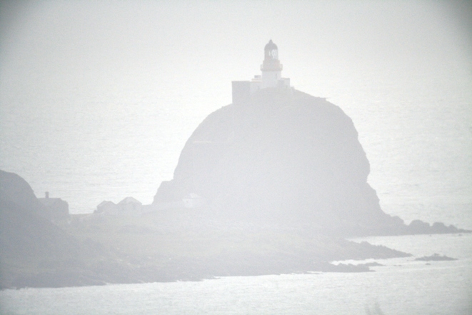
| M107 A4272 114-4244 |
Mull of Kintyre 2/20, 91m, 24 miles NR587085 |
 Station established by Thomas Smith, 1788: the second light authorised by and constructed
for the Northern Lighthouse Board.
Rebuilt 1830 Station established by Thomas Smith, 1788: the second light authorised by and constructed
for the Northern Lighthouse Board.
Rebuilt 1830White tower on white building 12m Visible 178° though 090° to 347° Often said to be the most southerly point of Kintyre, but in fact a mile and a half north, on the west coast and visible only to the west. It is in fact intended as a landfall light for vessels making from the Atlantic to the North Channel. The fact that it stands close to a headland called South Point only adds to the confusion LR68; EX356; CH (small-scale) 4102, (2), 1121, 2635, 2724,(medium-scale) 2126, 2199, 2798 Access on foot from carpark at top of (very) steep hill |
| M108 A4274 114-4248 |
Sanda 1/10, 50m, 15 miles NR726037 |
 White tower 12m on steep-sided rock (the Ship Rock) White tower 12m on steep-sided rock (the Ship Rock)
Visible 178° though 090° to 347° Established 1850 (Alan Stevenson), modernised 1852. Visible from one point (about six miles distant) on the mountain road leading to M107 Mull of Kintyre, and so included in this Section. Reference numbers on all subsequent towers have been increased by one. A better picture will be provided when Michael gets there with the Sun in the south! LR68; EX356; CH (small-scale) 2, 1121, 2635, 2724, (medium-scale) 2126, 2126·1, 2199, 2798, Access to the island by boat. The tower is reached from the lightkeepers' cottages at the base of the rock by staircases within castellated stone towers. The entrance to the staircases is kept locked and there is no access to the tower. |
|
Campbeltown Tower light: | ||
| M109 A4276 114-4252 |
Island Davarr 2/10, 37m, 23 miles NR761206 |
 White tower 20m White tower 20mVisible 330° W through 180° to 073° LR68; EX356; CH (small-scale) (2), 1121, 2635, 2724, (medium-scale) 2126, (large-scale) 1864C Access on foot across drying spit |
Onastic lights: | ||
| M109-01 A4280 114-0 |
NATO Pier E QR, 7m, 1 mile NR741195 |
White post image LR68; EX356; CH (large-scale) 1864C No access |
| M109-02 A4280·2 114-0 |
NATO Pier W QR, 7m, 2 miles NR740195 |
White post image LR68; EX356; CH (large-scale) 1864C No access |
| M109-03 A4279 114-4256 |
Kilkerran Ldg Lts front FOr, 7m, 6 miles NR728195 |
Grey
metal post c. 7m with orange triangle point up below the lantern 6m. This and the rear light are listed by the Admiralty as Yellow,
but are in fact sodium vapour strip lights with the characteristic orange colour. Shown 24 hours. image LR68; EX356; CH (medium-scale) 2126, (large-scale) 1864C Access across foreshore |
| M109-04 A4279·1 114-4260 |
Kilkerran ldg lts rear FOr, 28m, 6 miles NR726194 |
Grey
metal post c. 7m with orange triangle point down above the lantern. Shown 24 hours. image LR68; EX356; CH (medium-scale) 2126, (large-scale) 1864C In field |
| M109-06 A4282 114-4268 |
New Quay NE end 2FR, 5m, 4 miles NR723203 |
post 4m image LR68; EX356; CH (large-scale) (1864C) No access |
| M109-05 A4284 114-4264 |
Old Quay SE end 2FG, 7m, 4 miles NR722204 |
post 5m image LR68; EX356; CH (large-scale) (1864C) Access on foot from car park on pier |
Carradale Onastic light: | ||
| M109-07 A4290 114-4272 |
Port Crannaich Breakwater Head R 1/10, 6m, 6 miles NR819388 |
Post 3m image LR68; EX356; CH (small-scale) 2724, (medium-scale) 2126, 2131 Access on foot along pier |
| The following light is new since 2012 and has an intermediate M-number, to avoid a lot of renumbering | ||
| M109-07-1 A4292 114-4272 |
Claonaig Ferry Slip WRG Iso/3, 5m, 4/4/4 miles NR875560 |
Post 3m image LR62; EX357; CH (medium-scale) 2221, 2131, 2383 Access on foot |
East Loch Tarbert see Loch Fyne plan Onastic lights: | ||
| M109-08 A4298 114-4284 |
Madadh Maol R 1/2·5, 4m, 3 miles NR872690 |
Red post on concrete base image LR62; EX357; CH (medium-scale) 2381, (small-scale) 2381B Access by boat only |
| M109-09 A4300 114-0 |
Fish Quay E end 2FR, 3m, 2 miles NR869689 |
Grey metal lamp standard 5m image LR62; EX357; CH (small-scale) 2381B Access on foot along pier |
| M109-10 A4299 114-4288 |
Eilean a' Choic SE QG, 3m, 2 miles NR867688 |
Green post image LR62; EX357; CH (small-scale) 2381B Access by boat only |
Ardrishaig Tower light: | ||
|
M110 A4304 114-4296 |
Breakwater Head
WRG Long/6, 9m, 4 miles NR855853 |
 White tower 6m White tower 6mflash 2 sec Sectors: 035° R 350° W 339° G 287° LR55; EX358; CH (medium-scale) 2131, 2381, 2381A Access on foot along breakwater |
| Onastic lights: | ||
| M110-01 A4304·05 114-0 |
Lock Entrance FR, ?m, ? miles NR853852 |
Fluted lamp standard 4m image (with M110 in the background) LR55; EX358; CH (medium-scale) 2381A Access on foot, close to main road |
| M110-02 A4304·1 114-0 |
Lock Entrance FG, ?m, ? miles |
Red post no image available -- Not found! -- unknown to the Harbourmaster after "some years" of service LR55; EX358 |
| M110-03 A4304·15 114-0 |
Lock Entrance FG, ?m, ? miles NR853852 |
Fluted lamp standard 4m image LR55; EX358; CH (medium-scale) 2381A Access on foot, close to main road |
| M110-04 A4304·2 114-0 |
Pier head 2FG, 3m, 4 miles NR854854 |
Galvanised steel lamppost 8m image LR55;EX358; CH (medium-scale) 2381, 2381A No access |
Loch Fyne Onastic lights: | ||
| M110-05 A4310 114-4304 |
Glas Eilean R 1/5, 12m, 7 miles NR911846 Same name as as M089-01 in Section G |
Red post on pedestal 3m image LR55; EX362; CH (medium-scale) 2131, 2381, 2382B Name not to be confused with MXXXX Glas Eileanan in the Sound of Mull Access by boat only |
| M110-06 A4317 114-0 |
Newton: transit lights in line ft Directional 208·5° FW, 17m, ? miles NS052988 |
Stayed wooden bipod structure
about 12m, with large platform
bracketed to upper part of legs and protected metal ladder; occasional image alternative image showing detail of platform LR56; EX360, 363; CH (medium-scale) 2131, 2382A Not to be confused with Newton Jetty on North UistNo access -- in dense woodland on private ground |
| M110-07 A4317·1 114-0 |
Newton: transit lts in line rear Directional 208·5° FW, 90m, ? miles NS044974 |
Stayed wooden
bipod structure exactly like front light; occasional image alternative image Arrangement of searchlights slightly different from front light LR56; EX360, 362; CH (medium-scale) 2131 At roadside just W of Leanach |
Some of the lights in Loch Fyne are owned and operated by the Clyde Port Operations authority rather than the Northern Lighthouse Board. Their characteristic structure, called by Michael a "Clyde Tower," consists of a cylindrical drum maybe fifteen feet high, standing on four short legs on a base and supporting a short post or framework carrying the lantern. They receive M-numbers as towers. Most such structures appear in Section K. Tower lights: | ||
|
M111 A4314 114-4308 |
Sgeir an Eirionnaich once called Paddy Rock WR 1/3, 7m, 8 miles NR995953 |
 Clyde
tower: framework mast on black round
tank with white stripes 7m Clyde
tower: framework mast on black round
tank with white stripes 7m
Sectors: 210° W 044° R 087° W 192° R 210° LR55; EX362; CH (medium-scale) (2131,) 2381, 2382B Access by boat only |
|
M112 A4308 114-4300 |
Otter Spit G 1/3, 7m, 8 miles NR911848 |
 Clyde
tower: short green post on green round
tank on concrete pyramid 11m Clyde
tower: short green post on green round
tank on concrete pyramid 11mLR55; EX362; CH (medium-scale) 2131, 2381, 2382B Access by boat only |
Portavadie Onastic lights: | ||
| M112-01 A4297·5 114-4282 |
Eilean na Beithe WRG 1/3, 7m, 5 miles NR920700 |
Metal post on concrete base 3m Sectors: 196° R 078° W 065° G 036° image LR62; EX362 inset; CH (medium-scale) (2131), 2381 Access by boat only |
| M112-02 A4297 114-4280 |
Breakwater 2FG, 6m, 4 miles NR923696 |
Metal post 4m image LR62; EX362; CH (medium-scale) (2131), 2381 Access on foot from public slip |
| M112-03 A4296·55 114-0 |
Marina W breakwater R 1/2, 6m, 2 miles NR926691 |
Metal post on dolphin
3m image LR62; EX362; CH (medium-scale) (2131), 2381 No access |
| M112-04 A4296·5 114-0 |
Marina E breakwater G 2/8, 6m, 4miles NR926691 |
Metal post on dolphin 3m image LR62; EX362; CH (medium-scale) (2131), 2381 No access |
| Hybrid light: | ||
|
M113 A4296 114-4276 |
Sgat Mor 1/3, 9m, 12 miles NR930665 |
 Clyde tower: White round lanternhouse on white tank, on concrete base
8m Clyde tower: White round lanternhouse on white tank, on concrete base
8mLR62; EX362; CH (small-scale) 2724, (medium-scale) (2131), 2381, 2383 Alternative image showing the hybrid nature of the tower Access by boat only |
| Disused tower: | ||