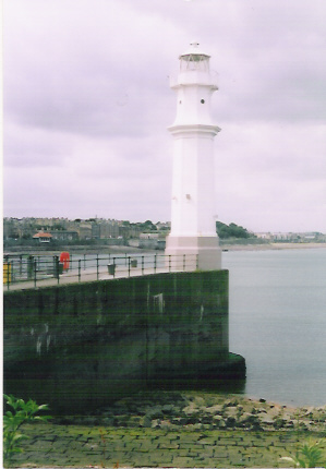
| Burnmouth Access by minor road to harbour; parking at root of piers Tower light: | ||
| M001-D -- |
E Pier head discontinued before 1970 (in 1954) FW, 6m, 4 miles |
 Established
1931. Rusty, once-white cylindrical metal tower about 2m high, standing on harbour wall Established
1931. Rusty, once-white cylindrical metal tower about 2m high, standing on harbour wallAccess by walking along pier NT959611 LR67; EX346; no longer charted |
| Onastic lights: | ||
| M001-01 A2837 114-0 |
W Pier root 2FG, 6m, ? |
Post 4m. Grey metal post (not wooden as in Admiralty list) standing on hillside about
10m away from root. Green bulbs in white circular lanterns At roadside image NT958609 LR67; EX346; CH (MSc) 160 |
| M001-02 A2834 114-2292 |
Leading front 241° FR, 29m, 4 miles |
Post 2m. Red glass lantern At roadside image NT957610 LR67; EX346; CH (SSc) 1192, 1407, (MSc) 160 |
| M001-03 A2834·1 114-2296 |
Leading rear 241° FR, 35m, 4 miles |
Pole 2m (part of telegraph pole, lower part only painted white).
Red bulb in white circular lantern (same pattern as -02) At roadside image LR67; EX346; CH (SSc) 1192, 1407, (MSc) 160 |
Eyemouth: the harbour was improved, new breakwaters were built and a mile-long access road bypassing the town was constructed in 1965. All the lights at Eyemouth probably date from this time. Parking at root of piers. All lights except M001-09 accessible by walking along piers Onastic lights: | ||
| M001-04 A2841 114-2308 |
E Breakwater head R Iso/2, 8m, 8 miles |
Post 5m image NT946647 LR67; EX346; CH (SSc) 1192, 1407, (MSc) 160, (LSc) 1612-9 |
| M001-05 A2843 114-0 |
Smeaton Quay head (entrance E side) QR, 4m, 3 miles |
Metal post, red and white bands, on metal dolphin image Accidentally destroyed 2008; all metalwork removed NT947645 LR67; EX346; CH (LSc) 1612-9 |
| M001-06 A2843·4 114-0 |
entrance W side QG, 4m, 1 mile |
Metal post, black and white bands, on wooden tripod image NT946645 LR67; EX346; CH (LSc) 1612-9 |
| M001-07 A2840·1 114-2304 |
West breakwater elbow Leading rear 174° FG, 10m, 6 miles |
Post 6m. Metal post with plate welded to front, all originally painted
orange and now peeling. Screen on harbour side of lantern image NT946645 LR67; EX346; CH (MSc) 160, (LSc) 1612-9 |
| M001-08 A2840 114-2300 |
West breakwater head Leading front 174° FG, 9m, 6 miles |
Post 4m. Metal post with plate welded to front, all originally painted
orange and now peeling image Front and rear lights together NT946646 LR67; EX346; CH (MSc) 160, (LSc) 1612-9 |
| Wall-mounted light: | ||
| M001-09 A2841·5 114-0 |
Promenade FR, 6m, ? |
Building. Lantern in circular medallion on gable end about 4m above
public road on north side of harbour. Traffic signal; shown when port closed. images NT946644 LR67; EX346; CH (LSc) 1612I-9 |
St Abbs Minor road leads to harbour; lights accessible on north pier Onastic lights: | ||
| M001-10 A2846·1 114-2316 |
Leading rear 165° FR, 4m, 1 mile |
Pole 10m image NT920673 LR67; EX346; CH (MSc) 160, 175 |
| M001-11 A2846 114-2312 |
Leading front 165° FR, 2m, 1 mile |
Post 2m image Front and rear lights together NT920673 LR67; EX346; CH (MSc) 160, 175 |
Tower light: | ||
|
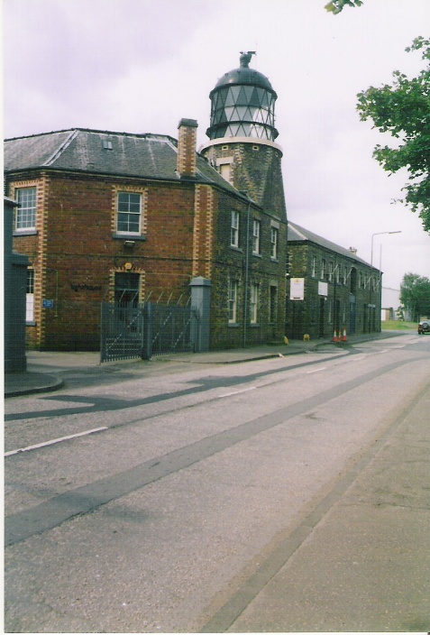
M002 A2850 114-2320 |
St Abbs Head 1/10, 68m, 29 miles |
 Established
1862 Established
1862Circular lanternhouse with black cupola, standing on white building, overall 9m Set on clifftop, with lantern tower and old foghorn considerably lower than domestic buildings Cliff edge not safely accessible: no entry to station enclosure. Seen from car park at end of narrow, twisting, steep and somewhat exposed single-track road branching off from access road to St Abbs village Alternative large image NT915692 LR67; EX346; CH (SSc) 2, 1192, 1407, 2182B, 4102, (MSc) 160, 175 |
Torness power station No public access (casual entrance to the power station is discouraged) Onastic lights: | ||
| M002-01 A2852 114-2324 |
Breakwater R 1/5, 10m, 5 miles |
Concrete column 2m. No image available NT747757 LR67; EX351E; CH (SSc) 1407, (MSc) 175 |
| M002-02 A2853 114-0 |
Leading front 215° G Iso/4, 6m, 6 miles Synchronised with rear |
White square with black vertical stripe, on concrete base 5m No image available NT742754 LR67; EX351E; CH (SSc) 1407, (MSc) 175 |
| M002-03 A2853·01 114-0 |
Leading rear 215° G Iso/4, 9m, 6 miles Synchronised with front |
White square with black vertical stripe, on metal post 1m No image available NT741753 LR67; EX351E; CH (SSc) 1407, (MSc) 175 |
Disused Tower: | ||
| M003-D A2854 114-2328 |
Barns Ness
discontinued 2005 (in 1930: 3/30, 25 miles) latterly Iso/4, 36m, 10 miles |
 Established 1901 Established 1901
White round tower 37m Private road about half a mile long, used as footpath from car park at caravan site at East Barns. No access to tower Alternative large image NT723772 LR67; EX351E; CH (SSc) 1407, (MSc) 175 |
Dunbar plan Onastic lights: | ||
| M003-01 A2860 114-2332 |
Middle Quay QR, 6m, 3 miles Visible through very constricted harbour entrance so effectively leading 132° |
Fluorescent strip light on metal post 5m Parking close by image image along leading line NT680793 LR67; EX351E; CH (MSc) 175, 734 |
| M003-02 A2856 114-2336 |
Leading front 198° G Oc/6, 15m, 3 miles Synchronised with rear Intensified in sector 208° to 188° |
Fluorescent strip light on square metal post 4m
with orange triangle point up On grass bank about 100 yards from M003-03 image NT677792 LR67; EX351E; CH (SSc) 1407, (MSc) 175, 734 |
| M003-03 A2856·1 114-2340 |
Leading rear 198° G Oc/6, 22m, 3m Synchronised with front Intensified in sector 208° to 188° |
Fluorescent strip light on square metal post 4m with orange triangle point down At roadside image View along leading line between Scart Rock and Castlefoot Rock (see plan) The front light is hidden by the grassy bank NT676791 LR67; EX351E; CH (SSc) 1407, (MSc) 175, 734 |
Tower light: | ||
|
M004 A2864 114-2344 |
Bass Rock 3/20, 46m, 10 miles (in 1930: 6/30, 21 miles) Visible 241° through N to 107° |
 Established
1902 Established
1902White tower on isolated rock 20m Access by boat only. Best seen from main road near Tantallon Castle NT602873 LR67; EX351E; CH (SSc) 2, 1407, 2182B, (MSc) 175, 734 |
North Berwick Onastic light: | ||
| M004-01 A2866 114-2348 |
N pier FWR, 7m, 3 miles Sectors W over harbour, R to seaward (boundaries not defined) |
Post 3m image NT554856 LR66; EX351E; CH (MSc) 175, 734 |
| Wall-mounted light: | ||
| M004-02 A2867 114-0 |
South harbour wall FG, 6m, 3miles |
Established after 1970. Bracket on building
image enlarged image NT553855 LR66; EX351E; CH (MSc) 175, 734 |
Tower light: | ||
|
M005 A2868 114-2352 |
Fidra 4/30, 34m, 15 miles (in 1930: 2/15, 16 miles) Obscured on some bearings by local islands Range reduced from 24 miles, 2011 |
 Established
1885 Established
1885 White brick tower on small island 17m Access by boat only. Minor road from Dirleton leads to car park; on foot across rough grass to shore NT512870 LR66; EX351W; CH (SSc) (2), 2182B, 1407, (MSc) 175, 734 |
Small ports Onastic lights: | ||
| M005-01 A2872 114-2356 |
Port Seton E pier WR Iso/4, 10m, 9/6 miles Sectors shore R 225° W 105° shore |
Rusty metal post 7m on white concrete conical base Clearly not "White metal framework tower" as described by Admiralty image NT405760 LR66; EX351W; CH (SSc) 1407, (MSc) 734, |
| M005-02 A2874 114-2360 |
Cockenzie Jetty QR, 6m, 1 mile |
Three-legged structure with vertical upper member 4m
No access; best seen from harbour at Port Seton image NT393758 LR66; EX351W; CH (MSc) 734 |
| M005-03 A2878 114-2364 |
Fisherrow E pier Oc/6, 5m, 6 miles |
Four-legged framework structure 3m
Parking at harbour; access on foot along pier image NT334731 LR66; EX350, 351W; CH (SSc) 1407, (MSc) 734, 735 |
Leith Disused tower: | ||
| M005A-D -- -- |
Tower Place -- |
 White octagonal cast-iron tower with black railed balcony 7m White octagonal cast-iron tower with black railed balcony 7m
Originally sited at Burntisland East Pier Head where (in 1954) it showed FR In pedestrian zone; street parking nearby; not visible from at sea so not charted NT272768 LR66; EX350 |
Tower light: | ||
| M006 A2884 114-2368 |
E breakwater head R Iso/4, 7m, 9 miles |
 Red lantern
on white concrete base 4m Red lantern
on white concrete base 4mShown 24 hours alternative large image also showing M006-01 on leftmost dolphin; from near Granton harbour at a distance of 2400 yards Only just a tower! No access: seen from outer end of housing estate NT263783 LR66; EX350; CH (SSc) 1407, (MSc) 734, 735, (LSc) 735-1 |
| Onastic lights: | ||
| M006-01 A2887 114-2374 |
Lead-in Jetty Or Long/6, --, -- The Admiralty lists this light as red, but it is actually orange, perhaps to help to distinguish it from the nearby M006 |
Short metal post 2m on dolphin Access as for M006 image NT263782 LR66; EX350; CH (MSc) 734, 735, 735-1 |
| M006-02 A2883 114-0 |
Deep Water Channel Dir 144·18° F and Alt WG 1/2, 8m, 2 miles Sectors: 148·84º FW (4°) 144·84º Alt W/G (1·32°) 143·82º FG (3·77°) 139·75º The indicated bearing is, unusually, in the middle of the alternating sector |
Metal post 4m no image available Access as for M006 NT264779 LR66; EX350; CH (MSc) 734, 735, 735-1 |
| Disused tower: | ||
| M007-D A2885·5 114-2372 |
W breakwater head discontinued 2008 (was G Long/6) |
 White
lantern on handrail of White
lantern on handrail ofwhite octagonal tower on roof of white building supported on concrete piles 6m Access as for M006 NT262780 LR66; EX350; CH (LSc) 735-1 |
Newhaven Disused tower: | ||
|
M008-D -- |
Newhaven discontinued (in 1930) FW, 16m, 12 miles |
 Established
1869 Established
1869White cast-iron tower 15m Parking nearby: access on foot along pier NT254772 LR66; EX350; CH (MSc) 735, (LSc) 735-1 |
Granton Tower light: | ||
| M009 A2904 114-2380 |
E breakwater head R 1/2, 5m, 6 miles |
 White
square brick tower 4m White
square brick tower 4mNT239779 LR66; EX350; CH (MSc) 734, 735, (LSc) 736 |
| Onastic lights: | ||
| M009-01 A2905 114-0 |
Middle Pier FG, 2m, 1 mile |
Metal post No image available NT239776 LR66; EX350; CH (MSc) 735, (LSc) 736 |
| M009-02 -- |
Middle Pier second light
discontinued after 1970 (was FR, 12m, 8 miles) |
Large green lantern on white concrete post 11m; external ladder to railed
balcony image NT238777 LR66; EX350; CH (LSc) 736 |
| NLB's Folly tower: | ||
|
M009-F -- |
Granton Old HQ -- |
 Black
lantern on gored circular tower rising from brick building
12m Black
lantern on gored circular tower rising from brick building
12mAt roadside; tower not open Originally the headquarters of the Northern Lighthouse Board, and intended for the testing of optical equipment. Now used by a film company NT234772 LR66; EX350; CH (MSc) 735, (LSc) 736 |
Hound Point Tanker Berth sketchplan Industrial installation in river: no access Onastic lights: | ||
| M009-03 A2918·9 114-0 |
No 2 NE 2FR, 7m, 5 miles |
Post on dolphin 4m image NT157803 LR65; EX350; CH (LSc) 736 |
| M009-04 A2918·8 114-0 |
No 2 E 2FR, 7m, 5 miles |
Post on dolphin 4m image NT156802 LR65; EX350; CH (LSc) 736 |
| M009-05 A2918·7 114-0 |
No 2 W 2FR, 7m, 5 miles |
Post on dolphin 4m No image available NT155802 LR65; EX350; CH (LSc) 736 |
| M009-06 A2918·2 114-0 |
No 1 E FR, 7m, 5 miles |
Dolphin No image available An aero light stands between Nos 9-06 and 9-07 NT152801 LR65; EX350; CH (LSc) 736 |
| M009-07 A2918·5 114-0 |
No 1 W FR, 7m, 5 miles |
Dolphin No image available NT150800 LR65; EX350; CH (LSc) 736 |
| M009-08 A2918·6 114-0 |
No 1 SW FR, 7m, 5 miles NY15799 |
Dolphin image NT150803 LR65; EX350; CH (LSc) 736 |
Forth Railway Bridge: plan The Admiralty divides the bridge into North and South cantilevers forming the North and South spans. In fact there are three cantilever towers, each pair connected by a bowstring girder bridge. Michael feels it clearer to remark on N and S spans alone. Lanterns are all mounted on or close to the bowstrings, bolted direct to the girders, without any supporting posts. At the positions of the outer lanterns in each span, the headroom under the bridge at high water is 150 feet, and the minimum depth of water at low tide in the main (north) channel is more than 200 feet. These requirements, which were placed on the designers of the bridge by the mid-Victorian Admiralty, make for a fairly large bridge: at the time of its construction, by far the largest in the world. Because the bridge is so large, it is not easy to photograph the lanterns with much clarity; and because they are apparently all identical, only a few are illustrated, and they must serve as models for all. The bridge is treated as if rooted on the south bank of the Firth. All lights are shown 24 hours. Publication 114 gives a single number 114-2416 to the complete collection of four FW and eight FR lanterns. No access, but visible from roads on both sides of river The Inchgarvie light, although very close to the NW corner of the northerly cantilever base, is not part of the bridge. It is now discontinued, but is still shown as M015-01 in Section B. Girder-mounted lights: | ||
| M009-09 A2925·7 114-2416 |
S span SE FR, 47m, 5 miles |
Lantern No image available NT136792 LR65; EX350; CH (LSc) 736 |
| M009-10 A2925 114-2416 |
S span central E FW, 47m, 5 miles |
Lantern No image available NT136793 LR65; EX350; CH (LSc) 736 |
| M009-11 A2924·2 114-2416 |
S span NE FR, 47m, 5 miles |
Lantern No image available NT135794 LR65; EX350; CH (LSc) 736 |
| M009-12 A2923·7 114-2416 |
N span SE FR, 47m, 5 miles |
Lantern No image available NT134797 LR65; EX350; CH (LSc) 728, 736 |
| M009-13 A2923 114-2416 |
N span central E FW, 47m, 5 miles |
Lantern No image available NT134798 LR65; EX350; CH (LSc) 728, 736 |
| M009-14 A2922·2 114-2416 |
N span NE FR, 47m, 5 miles NT1380 |
Lantern No image available NT134799 LR65; EX350; CH (LSc) 728, 736 |
| M009-15 A2922 114-2416 |
N span NW FR, 47m, 5 miles |
Lantern image The lantern is the small white cylinder in the V of the two girders, which are each about 2m across NT134799LR65; EX350; CH (LSc) 728, 736 |
| M009-16 A2922·7 114-2416 |
N span central W FW, 47m, 5 miles |
Lantern No image available NT134798 LR65; EX350; CH (LSc) 728, 736 |
| M009-17 A2923·2 114-2416 |
N span SW FR, 47m, 5 miles |
Lantern No image available NT134797 LR65; EX350; CH (LSc) 728, 736 |
| M009-18 A2924 114-2416 |
S span NW FR, 47m, 5 miles |
Lantern image NT135793 LR65; EX350; CH (LSc) 736 |
| M009-19 A2924·7 114-2416 |
S span centre W FW, 47m, 5 miles |
Lantern No image available NT136792 LR65; EX350; CH (LSc) 736 |
| M009-20 A2925·2 114-2416 |
S span SW FR, 47m, 5 miles |
Lantern image close-up NT136792 LR65; EX350; CH (LSc) 736 |
South Queensferry (properly called just Queensferry) plan Disused tower: | ||
|
M010-D -- |
Hawes Pier root discontinued perhaps 1877 |
 Established 1812
(John Rennie).
Hexagonal stone tower 7m with conical top and central flue for ventilation of oil light.
Originally had domed top with ball finial and may have reached 8m. Established 1812
(John Rennie).
Hexagonal stone tower 7m with conical top and central flue for ventilation of oil light.
Originally had domed top with ball finial and may have reached 8m.
Discontinued probably in 1877, since this date is believed to apply to the matching light M015 at North Queensferry (Section B). Not shown in Admiralty List of Lights 1930, having been superseded by next item Access on foot from car park nearby NT137784 LR65; EX350; CH (LSc) 736 |
| Onastic light: | ||
|
M010-01 A2925·9 114-0 |
Hawes Pier head FR, ?m, ?miles (in 1970: FW, 13ft, 4 miles; in 2012: Y Iso/2, 6m, ? miles) In 1970 the Admiralty used the reference A2925 for this light and A2922 for all the lights on the railway bridge (see M009-09, -10 and -20). The light was discontinued some time after 1970 and even though it has been reinstated it was some years before it was again listed by the Admiralty, with its new reference number. |
Established
probably 1877. Original structure was square-section,
tapering framework mast about 9m with ladder leading to railed platform surrounding lanternhouse similar to that at
Methil (M019, Section B). Shown in a photograph dated 1897 and reproduced in the Illustrated Atlas of Victorian and Edwardian Britain (Automobile Association 1991) but unfortunately not shown here for copyright reasons -- but see sketch. Replaced by present structure in 1927: smaller tapering yellow metal framework mast mounted on square wooden frame image More recently the metal framework has been painted red as shown here NT135787 LR65; EX350; CH (LSc) 736 Access along slipway at low water from car park nearby |
Forth Road Bridge: plan Lanterns on the bases are mounted on short posts close to the feet of the towers. It rather looks as if they can only be reached by boat! Lanterns on the spans are mounted on very short posts fixed to the bottom chord of the span, surrounded by a guard railing, and reached by metal stairways (not open to the public) leading down from the external walkway. Their positions are marked by day by short orange bands on the span. They (and the tower base lights) are visible only upstream or only downstream, depending of course on which side of the bridge they stand. Like the railway bridge, the road bridge is so large that it is not easy to photograph the lanterns with much clarity; and because they apparently fall into only two classes, those on the tower bases and those mid-span, only a few are illustrated, and they must serve as models for all. The bridge is treated as if rooted on the south bank of the Firth. Publ. 114 ignores the bridge altogether. Onastic lights: | ||
| M010-02 A2932 - |
S tower base E R Iso/4, 7m, 6 miles |
Short metal post image Aero lights above NT125791 LR65; EX350; CH (LSc) 736 |
| M010-03 A2930 - |
Main span S part E QR, 49m, 6 miles |
Underside of span No image available (but see M010-10) NT125794 LR65; EX350; CH (LSc) 736 |
| M010-04 A2929 - |
Main span centre E Iso/4, 50m, 8 miles |
Short (perhaps 1m) metal post on lower chord image NT125796 LR65; EX350; CH (LSc) 728, 736 |
| M010-05 A2928 - |
Main span N part E QG, 49m, 6 miles |
Short (perhaps 1m) metal post on lower chord image NT126799 LR65; EX350; CH (LSc) 728, 736 |
| M010-06 A2926 - |
N tower base E G Iso/4, 7m, 6 miles |
Short metal post images Aero lights above NT126801 LR65; EX350; CH (LSc) 728, 736 |
| M010-07 A2926·2 - |
N tower base W G Iso/4, 7m, 6 miles NT125801 |
Short metal post image Aero lights above NT125791 LR65; EX350; CH (LSc) 728, 736 |
| M010-08 A2928·2 - |
Main span N part W QG, 49m, 6 miles |
No image available NT125799 LR65; EX350; CH (LSc) 728, 736 |
| M010-09 A2929·2 - |
Main span centre W Iso/4, 50m, 8 miles |
No image available NT125796 LR65; EX350; CH (LSc) 728, 736 |
| M010-10 A2930·2 - |
Main span S part W QR, 49m, 6 miles |
Short metal post image The lantern on its post can be seen above the yellow marker; the lantern on the other side, listed here as M010-03, can be seen through the girders NT125794 LR65; EX350; CH (LSc) 736 |
| M010-11 A2932·2 - |
S tower base W R Iso/4, 7m, 6 miles |
Short metal post image Aero lights above NT125791 LR65; EX350; CH (LSc) 736 |
Reference M011 no longer used Port Edgar plan Numerous FR lights on the pontoons in the marina are not listed here Publication 114 shows this light as Directional 244°, biut it was changed to an all-round light between 1970 and 2000. Tower light: | ||
| M012 A2934 114-2420 |
W breakwater R 1/4, 4m, 8 miles |
 Short metal
post on white blockhouse 3m Short metal
post on white blockhouse 3mNT120792 LR65; EX350; CH (LSc) 736 |
The new Forth Crossing (which will be called the Queensferry Bridge) will be rooted here. At present the works in the river are lit only by numerous Y buoys and by the replacements M013-11, 12 for Beamer Rock (listed in Section B). It is not yet clear what other fixed lights will be established on or close to the bridge, and the M-references M012-01 to -20 are reserved for them. New lights at Grangemouth complicate the resulting renumbering, as follows:
| ||
Bo'ness Onastic lights: | ||
| M012-21 A2954 114-2466 |
Carriden Outfall Y 1/5, --, 3 miles |
Yellow pile 2m Access only by boat image (about half a mile) NT028821 LR65; EX367W; CH (LSc) 737 |
| M012-22 A2955 114-0 |
E pier 2FR, 11m, 3 miles |
Metal post Access across grass from car park nearby image NS999820 LR65; EX349E, 367W; CH (LSc) 737 |
| M012-23 A2955·1 114-0 |
W pier 2FG, 11m, 3 miles |
Metal post Access as for M012-02 image NS998820 LR65; EX349E, 367W; CH (LSc) 737 |
| M012-24 A2958 114-0 |
Bo'ness Outfall Y 1/5, 3m, 2 miles |
Yellow pile framework 8m Access only by boat image NS002831 LR65; EX367W; CH (LSc) 737 |
Grangemouth Access to the three identical structures M012-25 to -27 by boat only; no public access to M012-28 to -33 (within port installation) Onastic lights: | ||
| M012-25 A2960 114-2472 |
No 1 R 3/10, 4m, 6 miles |
Black metal pile with red cylinder On edge of dredged channel; cylinder has footholds for access image NS982837 LR65; EX367W; CH (LSc) 737 |
| M012-26 A2962 114-2480 |
No 3 R 1/4, 4m, 3 miles Chart 737 has 6 miles) |
Black metal pile with red cylinder On edge of dredged channel; cylinder has footholds for access image see M012-05 NS971840 LR65; EX367W; CH (LSc) 737 |
| M012-27 A2964 114-2488 |
No 5 R 1/2, 4m, 5 miles |
Black metal pile with red cylinder On edge of dredged channel; cylinder has footholds for access image see M012-05 NS963840 LR65; EX367W; CH (LSc) 737 |
| M012-28 A2970 114-0 |
Outer gates E FR Shows to seaward only |
Mast Traffic signal No image available NS9532838 LR65; EX367W; CH (LSc) 737, 741-3 |
| M012-29 A2970·6 114-0 |
Inner gates E FR Shows into the dock only |
Mast Traffic signal No image available NS950837 LR65; EX367W; CH (LSc) 737, 741-3 |
| M012-30 A2970·9 114-0 |
Eastern Channel No 1 R 1/5, 5m 1 mile |
Metal trestle on dolphin No image available NS950836 LR65; EX367W; CH (LSc) 741-3 |
| M012-31 A2970·92 114-0 |
Eastern Channel No 2 R 1/5, 5m, 1 mile |
Metal trestle on dolphin No image available NS949836 LR65; EX367W; CH (LSc) 741-3 |
| M012-32 A2970·8 114-0 |
Inner gates W FG |
Mast Traffic signal No image available NS950837 LR65; EX367W; CH (LSc) 737, 741-3 |
| M012-33 A2970·4 114-0 |
Outer gates W FR Shows to seaward only |
Mast Traffic signal No image available NS952838 LR65; EX367W; CH (LSc) 737, 741-3 |
| M012-34 A2979 114-0 |
River Carron QG, 7m, 3 miles |
Stone cairn 7m Access by long walk along rough track on left bank of River Carron image NS944840 LR65; EX349E, 367W; CH (LSc) 737, 741-3 |