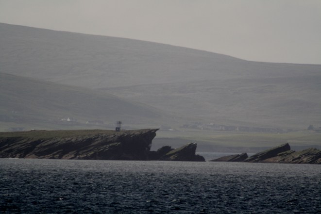
| Shetland mainland Tower light: | ||
| MQ01 A3766 114-3320 |
Sumburgh Head 3/30, 91m, 23 miles HU408079 |
 Established 1821
(Robert Stevenson). Established 1821
(Robert Stevenson). Present tower built 1914 (David A. Stevenson) White tower 17m and buildings LR4; EX466(S); CH2, 219, 245, 1119, 1239, 2182C, 3283 |
| Onastic light: | ||
| MQ01-01 A3767 114-3322 |
Pool of Virkie: E Breakwater 2FG, 6m, 5 miles HU401112 |
Square grey metal post 4m Coloured bulb in clear glass Shown 24 hours image LR4; EX466(S); CH3283 |
| Disused towers: | ||
| -- -- |
Brownies Taing discontinued before 1930 was FR, 5m, 5 miles HU423229 |
Tower no image available: nothing recognisable remains LR4; EX466(S); CH245, 3283 (not charted) |
| -- -- |
No Noss discontinued 1951 was 1/3.7, 56m, 15 miles HU4421 |
Established 1897
(David A. Stevenson) Modernised 1938 as white tower 6m. Discontinued 1951 when Perie Bard (MQ04) was established. Local information is that only the masonry base remains no image available LR4; EX466(S); CH245, 3283 (not charted) |
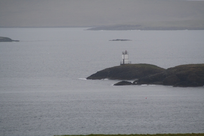
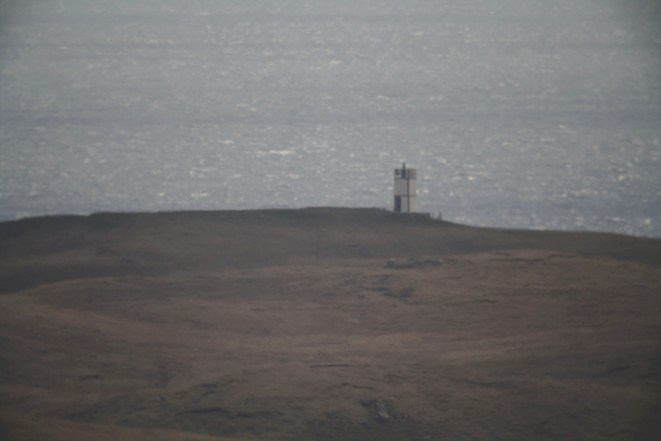
Isle of Mousa Tower light: | ||
|
MQ02 A3772 114-3324 |
Perie Bard (perhaps more correctly Peerie Bard) 1/3, 20m, 10 miles HU471239 |
 Established 1951 Established 1951Metal framework tower with white cladding 6m LR4; EX466(S); CH219, 1119, 1239, 3283 |
Shetland mainland, continued: Cunningsburgh Onastic lights: | ||
| MQ02-02 A3774 114-3326 |
Aith Voe R 1/3, 3m, 2 miles HU4382838 |
White metal post 2m image LR4; EX466(N); CH3283 |
| MQ02-03 A3774·2 114-0 |
Marina R 2/5, 4m, 2 miles HU |
Red metal post 2m image LR4; EX466(N) |
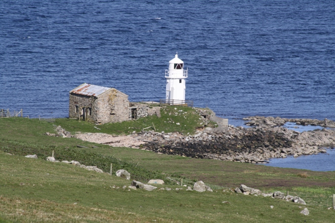
Isle of Bressay (clockwise) Disused tower light: | ||
| MQ03-D A3776 114-3340 |
Kirkabister Ness (was:) 2/20, 32m, 23 miles HU489376 |
 Established 1858 (David and Thomas Stevenson) Established 1858 (David and Thomas Stevenson)White tower 16m and buildings Originally lit with candles, later converted to run on paraffin, for which the equipment was renewed in 1940. Electrified 1967, automated 1988. Disconinued September 2012 and replaced by MQ03-A below The NLB donated the 1940 equipment to the Shetland Museum in Lerwick (see special page) LR4; EX466(N); CH2, 219, 1119, 1239, 2182C, 3271, 3272, 3283 |
| Tower light: | ||
| MQ03-A A3776 114-0 |
Kirkabister Ness 2/20, 18m, 10 miles HU489376 |
 Established 2012 Established 2012White tower about 3m with radar scanner on top; within the wall surrounding the station buildings: visible on the extreme right of the image (taken before the conversion) LR4; EX466(N); CH3271 (shown as circle marked "Radar Scanner" without magenta flash) Position of old tower shown on charts listed under MQ03-D above |
| Onastic lights: | ||
| MQ03-01 A3776·5 114-3342 |
Cro of Ham 1/3, 12m, 3 miles HU486395 |
Grey column 1m enclosed in white fence image alternative image LR4; EX466(N); CH3271, 3272, 3283 |
| MQ03-02 A3779 114-3348 |
Maryfield Ferry Terminal WRG Oc/6, 7m, 5 miles HU487417 |
White metal post 5m image Sectors shore G 008° W(5°) 013º R 111° G shore LR4; EX466(N), 467(E); CH3271, 3272, 3283 |
| MQ03-03 A3787·8 114-3402 |
Bay of Heogan: Quay head G 1/4, 6m, 3miles HU476432 |
Post 3m Publ.114 has A37983 which is no longer used no image available LR4; EX466(N), 467(E); CH3271, 3272 |
Mainland, continued Lerwick Harbour plan Tower light: | ||
| MQ04 A3778 114-3344 |
Twageos Point Long/6, 8m, 6 miles HU483408 |
 Established 1908 Established 1908Circular white concrete tower 2m on square concrete base flash 2 sec LR4; EX466(N), 467(E); CH3271, 3272, 3283 |
| Onastic lights: | ||
| MQ04-01 A3780 114-3352 |
Lifeboat Pier 2FR, 5m, 4 miles HU47834136 |
Grey lighting standard 8m image LR4; EX466(N), 467(E); CH3271, 3272 |
| MQ04-02 A3782 114-3356 |
Victoria Pier elbow 2FG, 5m, 4 miles HU47804139 |
Grey lighting standard 8m image LR4; EX466(N), 467(E); CH3271, 3272 |
| MQ04-03 A3781 114-3360 |
Victoria Pier head R 1/3, 5m, 1 mile HU47774147 |
Established 1919 Grey lighting standard 8m image LR4; EX466(N), 467(E); CH3271, 3272 |
| MQ04-04 A3783 114-3364 |
Spur Jetty QR, 5m, 1 mile HU47704155 |
Grey lighting
standard 8m images LR4; EX466(N), 467(E); CH3271, 3272 |
| MQ04-05 A3783·4 114-3368 |
Oil Jetty 1/3, 5m HU476418 |
Post 2m mounted on hut, overall about 4m image LR4; EX466(N), 467(E); CH3271, 3272 |
| MQ04-06 A3784 114-3372 |
North Ness WG iso/4, 4m, 5 miles HU475420 |
Established 1902 White (rusty) metal post 3m on concrete blocks, standing on masonry pillar Sectors 301°T W 216°T G 158°T W shore image LR4; EX466(N), 467(E); CH3271, 3272 |
Isolated Rock Onastic light: | ||
| MQ04-07 A3786 114-3376 |
Loofa Baa S Cardinal, 4m, 5 miles HU475423 |
Established 1913. Post on black concrete beacon
with yellow top 6m. Lantern mounted directly on concrete structure; S Cardinal mark on separate post alongside The underlying rock has a foot of water over it at low water springs, and so the concrete beacon is a genuine wave-washed tower! -- but not hollow image LR4; EX466(N), 467(E); CH3271, 3272 |
Mainland, Lerwick Harbour, continued Onastic lights: | ||
| MQ04-08 A3787 114-3377 |
Shearers Quay 2FR, 4m, 1 mile HU47164196 |
Grey metal
lighting standard 5m image LR4; EX466(N), 467(E); CH3271, 3272 |
| MQ04-09 A3787·1 114-3378 |
Morrison Dock QG, 4m, 5 miles HU471421 |
Grey metal post 2m image LR4; EX466(N), 467(E); CH3271, 3272 |
| MQ04-10 A3787·2 114-3380 |
Holmsgarth Quay South light R 1/3, 8m, 2 miles HU469423 |
Grey metal post 2m on dolphin While work continues on the pier head, the single light on the outer dolphin is replaced by two, each on a grey metal post taped to the metal fence image showing North and South lights together LR4; EX466(N), 467(E); CH3271, 3272 |
| MQ04-11 A3787·2 114-3380 |
Holmsgarth Quay North light R 1/3, 8m, 2 miles HU469423 |
Grey metal post 2m on dolphin While work continues on the pier head, the single light on the outer dolphin is replaced by two, each on a grey metal post taped to the metal fence image LR4; EX466(N), 467(E); CH3271, 3272 |
| MQ04-12 A3787·4 114-3384 |
Holmsgarth Jetty Q2R/8, 6m, 2 miles HU468425 |
Grey lighting standard 8m image LR4; EX466(N), 467(E); CH3271, 3272 |
| MQ04-13 A3787·6 114-3394 |
Gremista Marina S Breakwater head R iso/4, 3m, 2 miles HU467431 |
White post 2m Publ.114 has A3789 which is no longer used LR4; EX466(N), 467(E); CH3271, 3272 |
| MQ04-14 A3787·7 114-3388 |
Gremista Quay Upper light R 1/3, 11m, 2 miles HU469433 |
Triangular lattice mast
with external protected ladder, carrying floodlights, about 25m image close-up image showing both lights MQ04-14 and -15 LR4; EX466(N), 467(E); CH3271, 3272 |
| MQ04-15 A3787·7 114-3388 |
Gremista Quay Lower light FR, 8m, ? miles HU469433 |
same structure,
about 3m below MQ04-14: height not the same as M06-14, as listed by Admiralty Publ.114 has the FR higher than the Fl.R images see MQ04-14 LR4; EX466(N), 467(E); CH3271, 3272 |
| MQ04-16 A3788 114-3392 |
North Entrance WRG Dir Oc/6, 27m, 8 miles HU477362 Dir 215° |
Tube-light on
triangular lattice mast 6m with illuminated orange triangle point up Sectors 221° G(5°) 216° W(2°) 214° R(3°) 211° image LR4; EX466(N), 467(E); CH3271, 3272 |
| MQ04-17 A3790 114-3396 |
Greenhead QR 4/10, 4m, 3miles HU472443 |
Grey metal post 2m image LR4; EX466(N), 467(E); CH3271, 3272 |
| MQ04-18 A3793·5 114-3403 |
Skibby Baas R 2/5, 3m, 3 miles HU474449 |
Grey column fixed to grey metal pile with railed platform 3m image LR4; EX466(N), 467(E); CH3271, 3272 |
| Tower lights: | ||
|
MQ05 A3776 114-3404 |
Easter Rova Head Upper light WRG 3/18, 12m, 12/9/9 miles HU476455 |
 Established 1904 (David A Stevenson). Modernised 1946 Established 1904 (David A Stevenson). Modernised 1946
Short black column on metal framework tower with white cladding 7m Notwithstanding the description in the Admiralty list, this light is mounted higher than the directional light (see close-up image) Synchronised with lower light; visible all round except where obscured by Rova Head Sectors 040° R 009° G 261·5° W 241° R 213° G 191° W(9°) 182° R 090° LR4; EX466(N), 467(E); CH219, 1119, 1233, 1239, 3271, 3272, 3282, 3283 |
|
MQ05-01 A3794 114-0 |
Easter Rova head Lower light Dir WRG 3/18, 14m, 16/13/13 miles HU476455 Dir 186·5° |
Tube-light on same structure Images see MQ05 (also see note regarding relative height of mounting) Synchronised with upper light Sectors 196·5° G(5·5°) 191° W(9°) 182° R(5·5°) 176·5° (note that these partly overlap some of those on the upper light, so that in these sectors two separate lanterns are visible, though perhaps difficult to distinguish) LR4; EX466(N), 467(E); CH3271, 3272, 3282, 3283 |
| Onastic lights: | ||
| MQ05-02 A3795·5 114-3406 |
Dales Voe east side 2FR, 8m, 3 miles HU457457 |
Grey metal post 5m (not
metal lighting column 30m as listed by Admiralty: that column is on the left of the image) image LR4; EX466(N), 467(E); CH3271, 3272, 3282, 3283 |
| MQ05-03 A3795 114-3405 |
Dales Voe west side Dir WRG 2/8, 5m, 4/3/3 miles HU452461 Dir 230° |
Tube-light bracketed from stayed black metal column 2m Sectors 240° R(7°) 233° W(6°) 227° G(7°) 220° image LR4; EX467(E); CH3271, 3272, 3282, 3283 |
| MQ05-04 A3795·6 114-3406·5 |
Lax Firth pier 2FG, 4m, 2 miles HU44274781 |
Rusty metal post 3m image LR3; EX467(E); CH3272, 3282, 3283 |
Isolated Rock Tower lights: | ||
|
MQ06 A3795·7 114-3407 |
Hoo Stack Upper light WRG 4/12, 40m, 7/5/5 miles HU505520 |
 Metal
framework tower 8m with white cladding Metal
framework tower 8m with white cladding
Synchronised with lower light Sectors 193° G(9°) 184° W(4°) 180° R 169° W 193° LR3; EX467(E); CH219, 1119, 1233, 1239, 3272, 3282, 3283, 3284 (EXplorer and the charts do not agree on the position: as can be seen from the image, the tower is near the summit of the island) |
|
MQ06-01 A3795·7 114-3407 |
Hoo Stack Lower light Dir WRG 4/12, 40m, 9/6/6 miles HU505520 Dir 182° |
Same structure There is insufficient detail in the images available to resolve the two lights; but see MQ05 for a likely scenario Synchronised with upper light Sectors 187° G(3°) 184° W(4°) 180° R(3°) 177° (note that these sectors partly overlap those of the upper light--see note at MQ7-01) EX467(E); CH3272, 3282, 3283, 3284 |
Mainland, continued Tower light: | ||
|
MQ07 A3796 114-3408 |
Moul of Eswick WRG 1/3, 50m, 9/6/6 miles HU500534 |
 Established 1904 (David A Stevenson). Modernised 1935 Established 1904 (David A Stevenson). Modernised 1935White tower 7m Sectors shore R 028° W(10°) 018° G 207° W(7°) 200° R shore LR3; EX467(E); CH219, 1119, 1233, 1239, 3272, 3282, 3284 |
| Onastic light: | ||
| MQ07-01 A3805 114-0 |
Laxo Voe pier (Dury Voe) 2FG, 4m, 2 miles HU45876336 |
Grey metal lamp standard 5m image LR2, 3; EX468; CH3282, 3284 |
Offlying islets: Tower light: | ||
|
MQ08 A3811 114-3426 |
Lunna Holm WRG 3/15, 19m, 10/7/7 miles HU528750 |
White round tower 8m no image available Sectors shore R 275° W 209° G 094° W(4°) 090° R shore LR2, 3; EX468; CH1119, 1239, 3282, 3284, 3292, 3298 |
| Onastic lights: | ||
| MQ08-01 A3812·5 114-3429 |
Linga WRG Q4/8, 10m, 7/4/4 miles HU467740 |
Concrete column 2m synchronised with directional light image see MQ08-02 Sectors 312° W 196° G 154° and 146° R 092° LR2, 3; EX468; CH3282, 3284, 3292, 3298 |
| MQ08-02 A3812·5 114-3429 |
Linga WRG Dir Q4/8, 10m, 9/9/9 miles HU467740 Dir 150° |
Concrete column about 1.5m synchronised with all-round light image Sectors 155° G(3°) 152° W(4°) 148° R (3°) 145°. Notice that the directional light fills in the gap in the sectors of the main light and the two do not overlap LR2, 3; EX468; CH3282, 3284, 3292, 3298 |
Shetland Mainland, continued: Tower light: | ||
|
MQ09 A3812 114-3428 |
Firths Voe WRG Oc/8, 9m, 15/10/10 miles HU454747 |
 Established 1909 (David A Stevenson) Established 1909 (David A Stevenson)White tower 8m Sectors shore W 339° R 261° W(4°) 257° G 194° W(5°) 189° LR2, 3; EX468; CH1233, 3282, 3284, 3292, 3298+ |
| Onastic lights: | ||
| MQ09-01 A3813·56 114-0 |
Toft South Entrance 2QR/5, 5m, 1 mile HU437761 |
Grey post with red square on metal pile 3m image Visible 095° to 127·5° LR2, 3; EX468; CH3298 |
| MQ09-02 A3813·2 114-0 |
Toft Terminal Directional WRG Oc/10, 8m, 2/1/1 miles HU438761 Dir 241° |
White metal post with external ladder 6m image (also shows MQ09-03) Sectors 246° R(4°) 242° W(2°) 240 G(4°) 236° LR2, 3; EX468; CH3298 |
| MQ09-03 A3813·55 114-0 |
Toft South Jetty head 2FG, 7m, 1 mile HU438761 |
Grey metal post with floodlights 5m image (also shows MQ09-02) LR2, 3; EX468; CH3282, 3298 |
| MQ09-04 A3813·5 114-3431 |
Toft North Jetty head 2FR, 7m, 1 mile HU437762 |
Grey metal lamp standard 5m image Visible 330° to 085° LR2, 3; EX468; CH3282, 3298 |
Eastern approaches to Sullom Voe plan Tower light: | ||
|
MQ10 A3815·3 114-3437 |
Mio Ness WR 2Q/10, 12m, 7/4 miles HU425792 |
White round tower 5m no image available Sectors shore W 282° R 238° W shore LR2, 3; EX468, 469(N) and(S);CH3281, 3282, 3298 |
Islands in the south of Yell Sound: Onastic light: | ||
| MQ10-01 A3815 114-3436 |
Brother Isle WRG Dir 4/8, 16m, 10/7/7 miles HU421815 Dir 329° |
Tube-light on concrete column 2m no image available Sectors 333·5° R(3·5°) 330° W(2°) 330° G(4·5°) 323·5° LR1, 2, 3; EX469(N); CH3281, 3282, 3298 |
| Tower light: | ||
|
MQ11 A3815·6 114-3438 |
Tinga Skerry G Q2/10, 9m, 5 miles HU414807 |
White round tower 5m no image available LR1, 2, 3; EX469(N); CH3281, 3282, 3298 |
| Onastic light: | ||
| MQ11-01 A3822·5 114-3472 |
Little Roe WR 3/10, 16m, 5/4 miles HU399798 |
White GRP structure, orange band 5m image Sectors 036° W (through N) 095·5° R 036° LR2, 3; EX469(N) and (S); CH3281, 3282, 3297, 3298 |
Shetland Mainland, continued: Sullom Voe East side plan Onastic lights: | ||
| MQ11-02 A3822·6 114-3504 |
Skaw Taing Ldg front WRG Oc/5, 21m, 8/5/5 miles HU395781 Ldg 150°·5 |
Orange and white GRP structure 5m no image available Sectors 288° W 169° R 154° W(7°) 147° G 078° W 049° (the marked direction is the reciprocal of that marked by MQ14 Ness of Queyfirth LR2, 3; EX469(N) and (S); CH3281, 3282, 3297, 3298 |
| Tower light: | ||
| MQ12 A3822·61 114-3505 |
Skaw Taing Ldg rear Oc/5, 35m, 8 miles HU397779 Ldg 150°·5 |
White round tower, fluorescent orange strip no image available Visible 156° to 145° (overlaps W sector of front light) LR2, 3; EX469(N) and (S); CH3281, 3282, 3297, 3298 |
| Onastic lights: | ||
| MQ12-01 A3823·8 114-3503 |
No 4 (West) Jetty 2FR, 7m, 3 miles HU382758 |
Post 2m no image available LR2, 3; EX469(S); CH3297, 3298 |
| MQ12-02 A3823·7 114-3502 |
No 1 (East) Jetty 2FR, 7m, 3 miles HU394748 |
Post 2m image LR2, 3; EX469(S); CH3297, 3298 |
| MQ12-03 A3823·64 114-3501 |
Construction Jetty 2FR, 9m, 3miles 397750 |
Post 3m image LR2, 3; EX469(S); CH3297, 3298 |
| MQ12-04 A3823·34 114-3499 |
Garths Pier G 2/5, 4m, 3 miles HU401737 |
Metal post image LR2, 3; EX468, EX469(S); CH3297, 3298 |
| MQ12-05 A3823·32 114-3498 |
Garths Voe Finger Pier Iso G/4, 4m, 3miles HU401738 |
Metal post image LR2, 3; EX468, EX469(S); CH3297, 3298 |
| MQ12-06 A3823·3 114-3487 |
Garths Voe Tug Jetty 2FG, 8m, 3 miles HU402739 |
Floodlighting mast image LR2, 3; EX468, EX469(S); CH3297, 3298 |
| MQ12-07 A3823·2 114-3496 |
Sella Ness QG, 14m, 6 miles HU398740 |
Grey column with external ladder and two platforms 11m Publ.114 refers to an earlier arrangement of lights on this structure, using both platforms image LR2, 3; EX469(S); CH3297, 3298 |
| MQ12-08 A3823·1 114-0 |
Sella Ness Tower FAlt WRG Dir Oc/10, 19m, 16/3/3 miles HU398738 Ldg 133°·5 |
Tube-light on white column 2m on roof of building image Shown 24 hrs: ranges by day are 2/1/1 miles Sectors 143°·5 R(7°) 136°·5 AltWR (2°) 134°·5 W(2°) 132°·5 AltWG(2°) 130°·5 G(7°) 123°·5 LR2, 3; EX469(S); CH3297, 3298 |
Isolated rock Onastic light: | ||
| MQ12-09 A3823·6 114-3516 |
Ungam VQ 2/5, 2m, 2 miles HU380747 |
White post 2m no image available LR2, 3; EX469(S); CH3297, 3298 |
Shetland Mainland, continued: Sullom Voe West side plan Onastic lights: | ||
| MQ12-10 A3822·29 114-3488 |
Fugla Ness West rear Iso/4, 45m, 14 miles HU369747 Ldg 212°·3 |
Grey lattice mast 16m with black trapezoid long side up Synchronised with front no image available LR2, 3; EX469(S); CH3297, 3298 |
| MQ12-11 A3822·31 114-3492 |
Fugla Ness East rear Iso/4, 45m, 14 miles HU370746 Ldg 202°·9 |
Grey lattice mast 16m with black trapezoid long side up Synchronised with front no image available LR2; EX469(S); CH3297, 3298 |
| MQ12-12 A3822·3 114-3484 |
Fugla Ness common front Iso/4, 27m, 14 miles HU372751 |
Grey lattice mast 10m with orange trapezoid long side down Synchronised with both rears (or may be two separate lights) no image available LR2, 3; EX469(S); CH3297, 3298 |
| MQ12-13 A3822·8 114-3512 |
Ness of Bardister WRG Oc/8, 20m, 9/6/6 miles HU371764 Ldg 312°·5 |
Orange and white GRP structure 5m no image available Sectors shore G 314°·5 W(4°) 310°·5 R 240° W 180°·5 LR2, 3; EX469(S); CH3297, 3298 |
| MQ12-14 A3822·1 114-3480 |
Gluss Isle rear FW, 69m, 19 miles HU369780 Ldg 194·7 |
Grey lattice mast with square
array of 60 lamps 22m Shown 24 hrs images LR2, 3; EX469(N) and (S); CH3281, 3282, 3297, 3298 |
| MQ12-15 A3822 114-3476 |
Gluss Isle front FW, 39m, 19 miles HU373794 Ldg 194·7 |
Grey lattice mast with square
array of 60 lamps 32m Shown 24 hrs images LR2, 3; EX469(N) and (S); CH3281, 3282, 3297, 3298 |
Island off-shore: Tower light: | ||
|
MQ13 A3821 114-3468 |
Lamba WRG 1/3, 30m, 8/5/5 miles HU386812 Ldg 290°·5 |
White tower 8m no image available Sectors 197° W 140° R 044° W 327° R 293° W(5°) 288° G 234° LR1, 2, 3; EX469(N) and (S); CH3281, 3282, 3298 |
| Onastic light: | ||
| MQ13-01 A3821 114-3468 |
Lamba WRG Dir 1/3, 24m, 10/7/7 miles HU386812 Ldg 290°·5 |
Concrete column 2m no image available Sectors 295°·5 R(2°·5) 293° W(5) 288° G(2°·5) 285°·5 (partially overlapping the sectors of the tower light) LR1, 2, 3; EX469(N) and (S); CH3281, 3282, 3298 |
Shetland Mainland, continued: Yell Sound West side Tower light: | ||
|
MQ14 A3820·5 114-3464 |
Quey Firth WRG Oc/6, 22m, 12/8/8 miles HU371824 Ldg 330°·5 |
White tower 5m no image available Sectors shore R 334° W(7°) 327° G 290 W shore. The marked direction is the reciprocal of that marked by MQ11-02 Skaw Taing (front) LR1, 2, 3; EX469(N); CH3281, 3282, 3298 |
| Onastic lights: | ||
| MQ14-01 A3820·7 114-0 |
Collafirth Pier 2FG, 6m, 3 miles HU358842 |
Metal post 5m image LR1, 2, 3; EX469(N); CH3298 |
| Folly Tower: | ||
| MQ14-F -- -- |
Collafirth Garden -- HU359843 |
White circular cast-iron tower on hexagonal masonry base 4m: in private garden: believed to have been brought from Whalsay image LR1, 2, 3; EX469(N) |
Islands off-shore: Onastic light: | ||
| MQ14-02 A3820 114-3460 |
Outer Skerry 1/6, 12m, 8 miles HU382854 |
White column, black bands,
external ladder image LR1, 2, 3; EX469(N); CH3281, 3282, 3298 |
| Tower lights: | ||
|
MQ15 A3819 114-3456 |
Little Holm Iso/4, 12m, 6 miles HU404862 |
 Metal
framework tower 7m with white cladding Metal
framework tower 7m with white claddingLR1, 2, 3; EX469(N); CH3281, 3282, 3298 |
|
MQ16 A3818 114-3452 |
Muckle Holm 4/10, 32m, 10 miles HU403888 |
 Metal
framework tower 7m with white cladding Metal
framework tower 7m with white claddingLR1, 2; EX469(N); CH3281, 3282, 3298 (EX and the chart do not agree on the position of the structure) |
Shetland Mainland, continued: Yell Sound West side Tower light: | ||
|
MQ17 A3817·5 114-3448 |
Point of Fethaland WR 3/15, 65m, 24/20 miles HU378947 |
White tower 7m no image available Sectors 340° W 206° R 160° W 103° R 080° LR1, 2; EX469(N); CH2, 219, 245, 1233, 1239, 2182C, 2182D, 3281, 3282, 3298 |
Isolated rock: Tower light: | ||
|
MQ18 A3817 114-3444 |
Gruney WR 1/5, 53m, 8/6 miles HU382968 |
White tower 7m no image available Sectors 012° W through west to 180° R 064° LR1; EX469(N); CH219, 1233, 1239, 3281, 3282, 3298 |