Out Skerries Bound Skerry Tower light | ||
| MP01 A3807 114-3420 |
Out Skerries 1/20, 44m, 20 miles HU701718 |
 Established 1854 (David Stevenson) Established 1854 (David Stevenson)White tower 30m Images courtesy Andy Strangeway LR2; EX468; CH2, 1119, 1233, 1239, 2182C, 2182D, 3282, 3284, -2 |
Grunay Tower light | ||
| MP02 A3807·5 114-0 |
"F" Dir WRG iso/2, 7m, 3 miles HU |
White tower 2m no image available Sectors 234°·5 G(9°) 225°·5 W(2°) 223°·5 R (8°·5) 215° LR2; EX468; CH3284, -2 |
Rocks in South Mouth Onastic lights | ||
| MP02-1 A3808·35 114-0 |
Orfans Holm W Card HU |
Perch no image available LR2; EX468; CH3284-2 |
| MP02-2 A3808·3 114-0 |
G 2/5, 3m, HU |
Green perch 3m no image available LR2; EX468; CH3284-2 |
| MP02-3 A3808·2 114-0 |
"A" VQG, 3m, 3 miles HU |
White perch no image available LR2; EX468; CH3284-2 |
Bruray Onastic lights | ||
| MP02-4 A3807·4 114-0 |
Ldg ft (west) FG, 7m, 1 mile HU Ldg 338° |
Grey concrete post with red triangle point up no image available LR2; EX468; CH3282, 3284-2 |
| MP02-5 A3807·41 114-0 |
Ldg rr (west) FG, 8m, 1 mile HU Ldg 338° |
Grey concrete post with red triangle point down no image available LR2; EX468; CH3282, 3284-2 |
| MP02-6 A3807·31 114-0 |
Ldg rr (east) FY, 12m, 2 miles HU Ldg 014° |
White hut, orange stripe no image available LR2; EX468; CH3284, -2 |
| MP02-7 A3807·3 114-0 |
Ldg ft (east) FY, 3m, 2 miles HU Ldg 014° |
White hut, orange stripe no image available LR2; EX468; CH3284, -2 |
| MP02-8 A3808·5 114-0 |
Ferry Pier Head 2FG, 6m, 4 miles HU |
Metal post 5m no image available LR2; EX468; CH3284, -2 |
| MP02-9 A3808 114-0 |
"B" VQR, 3m, 3miles HU |
White post no image available LR2; EX468; CH3284-2 |
| MP02-10 A3807·8 114-0 |
"C" R Oc/3, 3m, 3miles HU |
White post 3m no image available LR2; EX468; CH3284-2 |
| MP02-11 A3807·7 114-0 |
"D" R 3/6, 3m, 3 miles HU |
White perch no image available LR2; EX468; CH3284-2 |
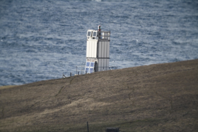
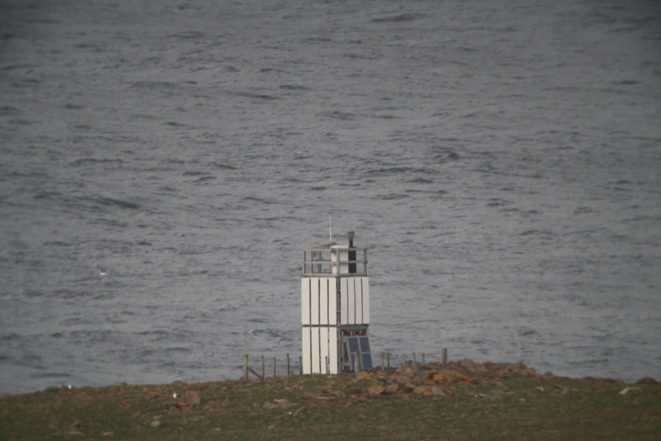
Isolated rock Tower light | ||
| MP03 A3810 114-3424 |
Muckle Skerry 2FG, 7m, 5 miles HU627734 |
no image available Sectors 272° G 348° W(5°) 353° R 046° W 192° R 272° LR2; EX468; CH1233, 1239, 3282, 3284, 3292 |
Whalsay group Offlying island Tower light | ||
| MP04 A3804·2 114-0 |
Wether Holm 1/5, 6m, 9 miles HU540658 |
no image available LR2, 3; EX468; CH3282, 3284 |
Mainland of Whalsay Tower light | ||
| MP05 A3804 114-3416 |
Kirk Ness (Suther Ness) WRG 1/3, 10m, 10/8/8 miles HU551653 |
Established 1904 (David A. Stevenson). Modernised 1936 no image available Sectors shore G 206° W 173° R 158° G 143° W(8°) 135° R 038° W shore LR2; EX468; CH3282, 3284 |
Offlying rock Onastic light | ||
| MP05-1 A3803·8 114-3413 |
Skate of Marrister G 1/6, 4m, 4 miles HU540639 |
no image available LR2; EX468; CH3282, 3284 |
Whalsay (continued) Onastic lights | ||
| MP05-2 A3803·35 114-0 |
Symbister N Pier R Oc/7, 3m, 3 miles HU538626 |
no image available LR2, 3; EX468; CH3284, -1 |
| MP05-3 A3803·5 114-0 |
Symbister Marina E 2FG HU539623 |
no image available LR2, 3; EX468; CH3284-1 |
| MP05-4 A3803·6 114-3584 |
Symbister Marina W 2FR HU537623 |
Beacon no image available LR2, 3; EX468; CH3284-1 |
| MP05-5 A3803 114-0 |
Symbister C Pier QG HU538625 |
Post 3m no image available LR2, 3; EX468; CH3284-1 |
| MP05-6 A3803·3 114-0 |
Symbister NW pier G Oc/7, 3m, 3 miles HU537626 |
no image available LR2, 3; EX468; CH3284, -1 |
Tower light | ||
| MP06 A3802 114-3412 |
Symbister Ness G/2, 7m, 5 miles HU532622 |
Established 1904 (David A. Stevenson). Modernised 1946 no image available LR2, 3; EX468; CH3282, 3284, -1 |
Disused Structure | MP06-1 -- -- |
Point of Harms was in 1930: FW, 16m, 6 miles HU |
White wooden hut no image available LR2, 3; EX468 |
Yell West coast Tower lights | ||
| MP07 A3816 114-3440 |
Bagi Stack 4/20, 45m, 10 miles HP479051 |
Metal framework tower 7m with white cladding no image available LR1; EX470(N); CH219, 1233, 1239, 2182C, 2182D, 3282, 3298 (the maps and the charts do not agree on the location) |
|
MP08 A3814 114-3432 |
Ness of Sound WRG 3/12, 18m, 9/6/6 miles HU447823 |
Metal framework tower 8m
with white cladding
Sectors shore G 165° W(5°) 160° R 350° W(5°) 345° G shore LR1, 2, 3; EX470(S); CH3282, 3298 |
Ulsta see plan An extraordinary collection of lights for such a small port, none of them a tower. The "manoeuvring basin" is used as a parking place for one of the ferries when the timetable does not require it; the lights on piles and tripods mark the edge of deep water. Three of the tripods (Nos 1, 2 and 4 counting from the shore) are unlit (see image showing Nos 1 and 2) Onastic lights | ||
| MP08-01 A3813 114-0 |
Breakwater head VQR, 10m, 2 miles HU46407941 |
Grey metal post on concrete base 10m, with floodlights about 3m image LR2, 3; EX468, 470(S); CH3282, 3292, 3298 |
| MP08-02 A3813·145 114-0 |
North jetty head 2FR, 7m, 1 mile HU46427947 |
Grey metal post 4m with floodlights about 3m, between the two fixed reds image LR2, 3; EX468, 470(S); CH3292, 3298 |
| MP08-03 A3813·143 114-0 |
Manoeuvring basin innermost Y/4, 5m, 1 mile HU46357952 |
Grey metal pile with platform 4m; metal post above supports yellow cross image LR2, 3; EX468, 470(S); |
| MP08-04 A3813·141 114-0 |
Manoeuvring basin (tripod No 3) Y/2, 5m, 1 mile HU46427950 |
White and grey metal post with platform on black and white tripod
4m; without topmark image LR2, 3; EX468, 470(S); |
| MP08-05 A3813·139 114-0 |
Manoeuvring basin (tripod No 5) QR, 5m, 1 mile HU46467944 |
White and grey metal post with platform on black and white tripod
4m; metal post above supports red square topmark image (also shows MP08-09, on the left) LR2, 3; EX468, 470(S); | MP08-06 A3813·137 114-0 |
Manoeuvring basin (tripod No 6) G Oc/2, 5m, 1 mile HU46487948 |
White and grey metal post with platform on black and white tripod
4m; metal post above supports green triangle topmark, point up image LR2, 3; EX468, 470(S); |
| MP08-07 A3813·135 114-0 |
Manoeuvring basin (tripod No 7) G/5, 5m, 1 mile HU46507948 |
White and grey metal post with platform on black and white tripod
4m; metal post above supports green triangle topmark, point up image (also shows MP08-08, on the right) LR2, 3; EX468, 470(S); CH | MP08-08 A3813·13 114-0 |
S Entrance No 1 G/3, 5m, 1 mile HU46517944 |
Grey metal pile with platform 4m;
metal post above supports green triangle topmark, point up image (also shows MP08-07, on the left) LR2, 3; EX468, 470(S); CH |
| MP08-09 A3813·129 114-0 |
S Entrance No 2 QG, 5m, 1 mile HU46537940 |
Grey metal pile with platform 4m;
metal post above supports green triangle topmark, point up image (also shows leading lights) LR2, 3; EX468, 470(S); CH |
| MP08-10 A3813·1 114-3430 |
Ldg ft WRG Oc/6, 10m, 4/3/3 miles HU46597943 Ldg 033°·8 |
White square metal post with grey platform
3m, enclosed within wooden fence image Synchronised with rear Sectors 052°·5 R 041°·25 W 026°·25 G 012° LR2, 3; EX468, 470(S); CH3282, 3292, 3298 |
| MP08-11 A3813·12 114-3430 |
Ldg rr Oc/6, 19m, 4 miles HU46667951 Ldg 033°·8 |
Grey metal column with platform 2m, painted white and
fading on forward face, enclosed in wooden fence
image Synchronised with front Visible 080° to 070° LR2, 3; EX468, 470(S); CH3282, 3292, 3298 |
| MP08-12 A3813·125 114-0 |
S Entrance No 3 (outermost) G/2, 7m, 2 miles HU46547933 |
Grey metal pile with platform 4m; metal post
above supports green triangle topmark point up image (also shows MP08-09, on the left) LR2, 3; EX468, 470(S); CH3282, 3292, 3298 |
Isolated rock Onastic light | ||
| MP08-13 A3812·8 114-3429·5 |
The Rumble 1/10, 8m, 4 miles HU484765 |
White concrete column 7m with square platform image LR2, 3; EX468; CH1233, 3282, 3292, 3298 |
|
Yell, continued Onastic lights | ||
| MP08-14 A3811·5 114-0 |
Burravoe pier 2FR HU52697969 |
Brown metal post 3m image LR2, 3; EX468, 470(S); CH3292, 3298 |
|
Tower light | ||
| MP09 A3824 114-3520 |
Whitehill WR 1/3, 24m, 9/6 miles HU547889 |
 Established
1904 (David A Stevenson). Modernised 1937 Established
1904 (David A Stevenson). Modernised 1937Metal framework tower 5m with white cladding (only the upper part of the tower is visible) The website of the Northern Lighthouse Board shows a circular metal tower and gives the date as 1980 Sectors shore R 352° W 211° R 163° W shore LR2; EX470(S); CH1233, 3282, 3292 |
|
Onastic lights | ||
| MP09-01 A3830·88 114-0 |
Basta Voe Pier R 1/5, 3m, 1 mile HU512980 |
Black metal column 3m image LR1; EX470(N) and (S); CH3292 |
| MP09-02 A3830·85 114-3530·1 |
Gutcher Dir WRG Oc/8, 4m, 2 miles HU54979931 Ldg 234° |
White circular concrete pedestal 1m images Sectors 246° R(10°) 236° W(4°) 232° G(10°) 222°. Shown 24 hours LR1; EX470(N) and (S); CH3282, 3292 |
| MP09-03 A3830·85 114-3530 |
Gutcher 2FR, 7m, 2 miles HU54979931 |
White metal post 6m image LR1; EX470(N) and (S); CH3282 |
| MP09-04 A3831·2 114-3532 |
Cullivoe Breakwater head WRG 2/10, 3m, 4 miles HP54970201 |
White metal post 2m image LR1; EX470(N); CH3282, 3292 |
| MP09-05 A3831·3 114-0 |
Cullivoe Pier (NE corner) 2FR, 4m, 3 miles HP54840211
|
White metal post 4m image Sectors 355° W 294° G 080° W 355° LR1; EX470(N); CH3292 |
Fetlar All the lights on Fetlar are at the ferry terminal. There are no tower lights Onastic lights | ||
| MP09-06 A3830·28 114-0 |
Outer Beacon QR2/5, 8m, 3 miles HU587944 |
Grey pile 4m with platform. Separate short red post supports red square topmark image Visible 275° through S to 095° LR1; EX470(S); CH3292 |
| MP09-07 A3830·24 114-0 |
Inner Beacon QR/5, 7m, 5 miles HU586944 |
Grey pile 4m with platform. Separate short red post supports red square topmark MP09-06 and 07 are visually identical image (also shows MP09-06 on the right) Visible 285° through S to 160° LR1; EX470(S); CH3292 |
| MP09-08 A3830·2 114-0 |
Pier Head 2FG, 5m, 3miles HU58639445 |
Grey metal post with floodlights 6m image Visible 050° through S to 090° LR1; EX470(S); CH3282, 3292 |
Unst Onastic lights | ||
| MP09-09 A3830·5 114-3530·5 |
Belmont Pier 2FG, 6m, 2 miles HP56470039 |
White square metal post bolted to concrete base 2m (listed by Admiralty as 5m) image LR1; EX470(N); CH3282, 3292 |
| MP09-10 A3830·4 114-0 |
Head of Mula WRG 1/5, 48, 10/7/7 miles HP56930001 Ldg 159°·25 and 359°·5 |
Stiffened grey metal post in metal framework structure 3m on
concrete base, surrounded by metal fence Directional through Bluemull Sound and Colgrave Sound images Sectors 161°·5 W(4°·5) 157° R 002° W(5°) 357° G 292° LR1; EX470(N); CH3282, 3292 |
|
Tower light | ||
| MP10 A3830 114-3528 |
Uyeasound 2/8, 7m, 5 miles HP588008 |
 Established 1946 Established 1946White circular concrete tower on beach 4m, with external steps to door. Grey metal framework 2m on roof, with external ladder access Overall about 6m LR1; EX470(N); CH3282, 3292 |
Balta Sound Onastic lights: | ||
| MP10-01 A3826 114-0 |
Sheetaberg QW HP |
no image available LR1; EX470(N); CH3299-1 |
| MP10-02 A3829 114-3526 |
Marina bwr head R/6, 2m, 2miles HP633091 |
Grey metal post 1m image LR1; EX470(N); CH3299-1 |
| MP10-03 A3828·5 114-0 |
Sandison's Wharf head 2FG, 7m, 2 miles HP6330896 |
Grey square metal post 4m image LR1; EX470(N); CH3299-1 |
| MP10-04 A3826·6 114-0 |
Sandison's Wharf knuckle WRG Dir Oc/10, 5m, 2 miles HP63440897 |
Grey square metal post on concrete plinth 4m image Sectors 297° R(10°) 287° W(5°) 282° G(10°) 272° LR1; EX470(N); CH3299-1 |
Islands and rocks: Tower lights: | ||
| MP11 A3828 114-3524 |
Balta WR 1/10, 18m, 10/8 miles HP658070 |
 Established 1895 (David A Stevenson). Modernised 1938 Established 1895 (David A Stevenson). Modernised 1938White metal framework tower with white cladding 5m Sectors 154° W 098° R 008° W 249° LR1; EX470(N); CH219, 1233, 1239, 3282, 3299-1 |
|
MP12 A3834 114-3542 |
Holm of Skaw 1/5, 8m, 8 miles HP668172 |
 White metal framework tower with white cladding
6m White metal framework tower with white cladding
6m
LR1; EX470(N); CH219, 1233, 1239, 3282 |
| MP13 A3832 114-3540 |
Muckle Flugga 2/20, 66m, 22 miles HP606197 |
 Established 1854 (David Stevenson: temporary building); 1857 (David and Thomas Stevenson:
permanent tower); modernised 1927 (David A Stevenson) Established 1854 (David Stevenson: temporary building); 1857 (David and Thomas Stevenson:
permanent tower); modernised 1927 (David A Stevenson) White tower 20m Almost the most northerly point of the United Kingdom: only Out Stack, about half a mile to the north-east, is further north, as it were LR1; EX470(N); CH2, 219, 245, 1233, 1239, 2182C, 2182D, 3282 |