| M135 is the Cloch Point light in Section K Ardrossan Onastic lights: | ||
| M135-11 A4532 114-4700 |
Approach: Dir 055° F and Alt WRG, 15m, 14/11/11 miles NS226426 |
Tube-light on metal framework structure 12m image Sectors (all very narrow!): 060° FR (1·2°) 058·8° Alt WR (2·6°) 056·2° FW (2·4°) 053·8° Alt WG (2·6°) 051·2° FG 1·2° 050° LR63, 70; EX341; CH (SSc) 2724, (MSc) 2126, 2131, 2221, 2491, (LSc) 1866A |
| M135-12 A4532 114-4700 |
same structure FR, 13m, 6 miles NS226426 |
Recognition image see M135-11; mounted below platform Visible 145° through 000° to 325° LR63, 70; EX341; CH (SSc) 2724, (MSc) 2126, 2131, 2221, 2491, (LSc) 1866A |
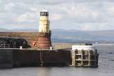
| M135-13 A4533 114-0 |
Traffic signals 3FR NS226423 |
Framework structure on roof of blue square
concrete tower with yellow chevrons, supporting harbourmaster's office Shown when harbour and marina closed; Shows 3FG when harbour only closed; shows FRRG when marina only closed image showing 3FG close-up image showing 3FG (the yellow mast is part of a ship) LR63, 70; EX341; CH (MSc) 2491, (LSc) 1866A | Tower light: |
| M136 A4538 114-4704 |
Lighthouse Pier head WG Iso/4, 11m, 9 miles NS222422 |
 Established 1840
White octagonal cast-iron tower 9m Sectors: 035° G 317° W 035° LR63, 70; EX341; CH (SSc) 2724, (MSc) 2126, 2131, 2221, 2491, (LSc) 1866A |
| M136-01 A4536 114-4708 |
N Breakwater head R 1/5, 7m, 5 miles NS222423 |
Red tripod 10m image Clearly not a "red gantry 1m" as described by Admiralty LR63, 70; EX341; CH (MSc) 2126, 2131, 2221, 2491, (LSc) 1866A |
Irvine The footbridge leads to the disused leisure centre on the north bank of the river. It closes by sliding bascules which apparently carry the deck-mounted lanterns; these are not visible while the bridge remains open, which has been the case for a number of years. (The opened bridge can be seen in the image for M136-09.) Other lanterns are mounted directly on the piers. The lights are charted by a single magenta flash at the centre of the span, wrongly labelled as 2FG instead of 2FR. The Admiralty references are duplicated on the north and south sides. Publication 114 ignores the bridge altogether Bridge-mounted lights: | ||
| M136-02 A4548·22 114- |
South side W end FR, 4m, 1 mile NS305382 |
On bridge pillar image LR70; EX333; CH (LSc) 1866B |
| M136-03 A4548·2 114- |
South face centre 2FR, 6m, 1 mile NS305382 |
On bridge deck no image available while bridge remains open LR70; EX333; CH (LSc) 1866B |
| M136-04 A4548·21 114- |
South side E end FG, 4m, 1 mile NS305382 |
On bridge pillar image close-up image of SE lantern LR70; EX333; CH (LSc) 1866B |
| M136-05 A4548·21 114- |
North side E end FG, 4m, 1 mile NS305382 |
On bridge pillar image see M136-04 above LR70; EX333; CH (LSc) 1866B |
| M136-06 A4548·2 114- |
North face centre 2FR, 6m, 1 mile NS305382 |
On bridge deck no image available while bridge remains open LR70; EX333;; CH (LSc) 1866B |
| M136-07 A4548·22 114- |
North side W end FR, 4m, 1 mile NS305382 |
On bridge pillar image see M136-02 above LR70; EX333; CH (LSc) 1866B |
| Onastic lights: | ||
| M136-08 A4548·1 1144728- |
Ldg lts rear FR, 15m, 5 miles NS306381 |
Grey mast 15m image Visible 120° through 000° to 019° LR70; EX333; CH (MSc) 2126, 2220, (LSc) 1866B |
| M136-09 A4548 114-4724 |
Ldg lts front FG, 10m, 5 miles NS305381 |
Green mast 10m image Visible 120° through 000° to 019° LR70; EX333; CH (MSc) 2126, 2220, (LSc) 1866B |
| M136-10 A4546 114-4716 |
Entrance, S side G 1/3, 6m, 5 miles NS300377 |
Green metal column with platform 6m image LR70; EX333; CH (MSc) 2126, 2220, (LSc) 1866B |
Troon Onastic lights: | ||
| M136-11 A4558 114-4740 |
E Pier head QR, 6m, 3 miles NS309318 |
Grey post on dolphin 4m image LR70; EX326, 333; CH (MSc) 2126, 2220, (LSc) 1866C | Tower light: |
| M137 A4554 114-4732 |
West Pier head WG 2/5, 11m, 9 miles NS308319 |
 Established 1840
White round tower 8m Sectors: 036° W through 180° to 090° G 036° LR70; EX326, 333; CH (SSc) 2724, (MSc) 2126, 2220, (LSc) 1866C |
| M137-01 A4555 114-4732 |
Traffic signal Y VQ NS308318 |
Grey lattice mast 14m image Shown when fast ferry in or approaching harbour LR70; EX326, 333; CH (LSc) 1866C |
| M137-02 A4555 114-0 |
Same structure FGWG (vertical), 8m, 4 miles NS308318 |
Grey lattice mast 14m image Shown when fast ferry in or approaching harbour LR70; EX326, 333; CH (LSc) 1866C | Lady Isle Tower light: |
| M138 A4562 114-4744 |
Lady Isle 1/2, 19m, 11 miles NS275293 |
 Established 1903 Established 1903White round tower, red stripes 5m LR70; EX326; CH (SSc) 2724, (MSc) 2126, 2131, 2220 |
Ayr Onastic lights: | ||
| M138-01 A4566 114-4764 |
North Breakwater head QR, 9m, 5 miles NS328228 |
Framework structure 9m image LR70; EX326; CH (MSc) 2126, 2220, (LSc) 1866E | Tower lights: |
| M139 A4574 114-4752 |
Leading lts front FR, 10m, 5 miles Leading 098° NS332226 |
Established 1790 Red round tower, white lantern 6m LR70; EX326; CH (MSc) 2126, 2220 (LSc) 1866E |
| M140 A4574·1 114-4756 |
Leading lts rear R Oc/10, 18m, 9miles NS334226 |
Established 1790 Masonry tower, white lantern 22m LR70; EX326; CH (MSc) 2126, 2220, (LSc) 1866E | Onastic light: |
| M140-01 A4574·2 114- |
Pontoon FW NS334224 |
image LR70; EX326; CH (LSc) 1866E | Tower lights: |
| M141 A4568 114-4760 |
S Pier head Q, 7m, 7 miles NS329227 |
Established 1877 White tower 6m Visible 161° through 090° to 012° LR70; EX326; CH (MSc) 2126, 2220, (LSc) 1866E |
| M141-01 A4568 114-4760 |
Same structure FG, 5m, 5 miles NS339227 |
image Visible 082° to 012° LR70; EX326; CH (MSc) 2126, 2220, (LSc) 1866E | Dunure Disused Tower: |
| M142 -- |
Pier root discontinued (was coal-fired) NS253160 |
 Established 1811 Established 1811Masonry tower Coal fire even at such late date. The wall alongside the fire opening acted as a crude form of sector boundary, leaving the fire invisible until a ship had cleared the dangers off the harbour entrance LR70; EX326; CH (MSc) (2126, showing place-name only) | Maidens Onastic lights: (established since 2013): |
| M142-01 A4577 114- |
Approach E side G 1/5, 4m, 3 miles NS212084 |
Post with green triangle point up image LR76; EX326; CH (MSc) (2126: showing place-name only) |
| M142-01 A4577·1 114- |
Approach W side R 1/3, 4m, 2 miles NS213084 |
Post with red square image LR76; EX326; CH (MSc) (2126, showing place-name only) | Tower light: |
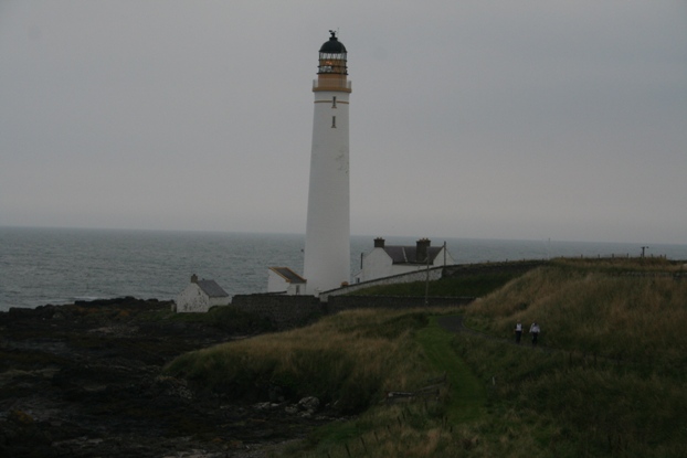
| M143 A4580 114-4772 |
Turnberry Point 1/15, 29m, 12 miles Range reduced from 24 miles NS196072 |
Established 1873 (David and Thomas Stevenson) White tower 24m LR70, 76; EX326; CH (SSc) 2, 1121, 2635, 2724, (MSc) 2126, 2199 |
| The Admiralty lists the light on Ailsa Craig at this point,
but since it is on an island about 9 miles from the coast, Michael lists it at the end of Section V Girvan Onastic lights: | ||
| M143-01 A4588·4 114-4778 |
N Breakwater head R 2/6, 7m, 4 miles NX180983 |
Post on concrete base 4m image LR76; EX326; CH (MSc) 2126, 2199, (LSc) 1866D |
| M143-02 A4586 114-4780 |
N Groyne head R 1/4, 5m, 2 miles NX182983 |
Framework structure image LR76; EX326; CH (MSc) 2126, 2199, (LSc) 1866D |
| M143-03 A4588 114-4776 |
S Pier head 2FG, 8m, 4 miles NX180983 |
Mast on white tower (hybrid light?) 6m image LR76; EX326; CH (MSc) 2126, 2199, (LSc) 1866D | Loch Ryan Onastic lights (established since 2013): |
| M143-04 A4591 114- |
Loch Ryan Port Leading front Iso/2, 6m, 9 miles (Range reduced by day to 1 mile) Leading 142° NX056700 |
Steel column image Visible 149·5º to 134·5° Synchronised with M143-06 LR76; EX326; CH (MSc) 1403, 1404, 2198, 2199, (LSc) 1404A |
| M143-05 A4591 114- |
Same structure 2FR, 6m, 3 miles NX056700 |
image
LR76; EX326; CH (MSc) 1403, 1404, (LSc) 1404A |
| M143-06 A4591·1 114- |
Leading rear Iso/2, 11m, 9 miles (Range reduced by day to 1 mile) NX058697 |
Framework tower image Visible 149·5º to 134·5° Synchronised with M143-04 LR76; EX326; CH (MSc) 1403, 1404, 2198, 2199, (LSc) 1404A | Tower light: |
| M144 A4592 114-4784 |
Cairn Point R 2/10, 14m, 12 miles NX061686 |
Established 1847 White tower with balcony 15m LR82; EX309; CH (MSc) 1403, 1404, 2198, 2199, (LSc) 1404A, 1403B |
| Onastic lights: | ||
| M144-01 A4594·2 114- |
Cairnryan Port N Breakwater 2FR, 5m, 3 miles NX069674 |
Post image LR82; EX309; CH (MSc)1403, 1404, (LSc) 1403B, 1404A |
| M144-02 A4594 114-4786 |
Mooring dolphin R 1/5, 5m, 5 miles NX069673 |
Mast image LR82; EX309; CH (MSc) 1403, 1404, 2198, 2199, (LSc) 1403B, 1404A |
| M144-03 A4594·4 114- |
Ramp tower 2FG, 12m, 2 miles NX071671 |
Post 2m image LR82; EX309; CH (MSc) 1403, 1404, (LSc) 1403B, 1404A |
Stranraer Onastic lights: | ||
| M144-04 A4595 114- |
Approach No 1 G Oc/6 NX065653 |
Beacon image LR82; EX309; CH (MSc) 1403, 1404 |
| M144-05 A4595·3 114- |
Approach No 3 QG NX062638 |
Beacon image LR82; EX309; CH (MSc) 1403, 1404 |
| M144-06 A4595·5 114- |
Approach No 5 G 1/3 NX058624 |
Perch image LR82; EX309; CH (MSc) 1403, 1404 |
| M144-07 A4597·2 114- |
East Pier head 2FR, 9m NX061615 |
Post image LR82; EX309; CH1403, (MSc) 1403, 1404 (LSc) 1403A, 1404B | The QR light formerly listed as A4597·5 and still charted on CH1403 and 1403A was discontinued on the removal in 2011 of the ferry terminal to Loch Ryan Port |
| M144-08 A4597 114- |
Ross Pier head 2FBlue NX060614 |
image LR82; EX309; CH (MSc) 1403, 1404, (LSc) 1403A, 1404B | The Rhinns Tower light: |
| M145 A4604 114-4796 |
Corsewall Point
5/30, 34m, 22 miles Before the fast ferries were established, this light exhibited the unusual character of WR Alt Long/74, with flashes 11sec long NW981726 |
Established 1817 (Robert Stevenson) White tower 34m Visible 257° through 180° to 027° LR76, 82; EX309; CH (SSc) 2, 1121, 2724, (MSc) 1403, 1404, 2198, 2199 | Disused Tower: |
| M146 A4606 114-0 |
Black Head discontinued 2007 (was 2/15, 49m, 25 miles) NW981564 |
Established 1900 (David A Stevenson) White tower 22m LR82; EX309; CH (SSc) 1121, 1411, 2724, (MSc) 2198 |
| Onastic light: | ||
| M146-01 A4607 114-4804 |
Portpatrick Ldg lts front FG Leading 050·5° NW999541 |
Post above orange stripe on sea wall Occasional image LR82; EX309; CH (MSc) (2198), 2198A |
| Wall-mounted light: | ||
| M146-02 A4607·1 114-4808 |
Portpatrick Ldg lts rear FG NX000542 |
Building with orange stripe Occasional image LR82; EX309; CH (MSc) (2198), 2198A | Disused tower: |
| M147 | Portpatrick Harbour
Discontinued by 1930 NW998539 |
Established 1913 White tower 6m LR82; EX309; CH (MSc) (2198), (2198A) | Tower lights: |
| M148 A4608 114-4812 |
Crammag Head
1/10, 35m, 18 miles NX089340 |
Established 1913 White tower 7m LR82; EX309; CH (SSc) 2, 1121, 1411, 2724, 2093, 2094, 2198 |
| M149 A4610 114-4816 |
Mull of Galloway
1/20, 99m, 28 miles NX157304 |
Established 1830 (Robert Stevenson) White round tower 26m Visible 105° through 000° to 182° LR82; EX309; CH (SSc) 2, 1121, 1411, 1826, 2724, (MSc) 2093, 2094, 2198 |
Port William Onastic light: | ||
| M149-01 A4620 114-4818 |
Ldg lts front G 1/3, 7m, 3 miles Leading 105° NX336437 |
Metal mast 6m image LR82; EX311; CH (MSc) 2094 |
| Wall-mounted light: | ||
| M149-02 A4620·1 114-4818·1 |
Ldg lts rear FG, 10m, 2 miles NX476365 |
Bracket on building image LR82; EX311; CH (MSc) 2094 |
Isle of Whithorn Onastic lights: | ||
| M149-03 A4624 114-4822 |
Ldg lts front R Oc/8, 7m, 7 miles Leading 335° NX476364 |
Orange metal mast with orange diamond 4m image LR83; EX311; CH (MSc) 2094 |
| M149-04 A4624·1 114-4823 |
Ldg lts rear R Oc/8, 9m, 7 miles NX476365 |
Orange metal mast with orange diamond 3m image LR83; EX311; CH (MSc) 2094 |
| M149-05 A4622 114-4820 |
E Pier head QG, 4m, 5 miles NX478362 |
Grey column image LR83; EX311; CH (MSc) 2094 | Tower light: |
| M150 A4624·2 114-4823·5 |
Fort WR 1/3, 20m, 6/4 miles NX481361 |
White square tower on fort 4m LR83; EX311; CH (MSc) 2094 Sectors: 040° R 055° W 310° (reported unreliable) | Garlieston Onastic light: |
| M150-01 A4630 114-4824 |
Pier head 2FR, 8m, 3 miles NX482463 |
Column 5m image LR83; EX311; CH (MSc) 2094 | Little Ross Island Tower light: |
| M151 A4634 114-4827 |
Leading lts rear 1/5, 50m, 12 miles NX660432 |
White tower 20m LR83, 84; EX312; CH (SSc) 1826, 1344, 1346, (MSc) 2094, (LSc) 1344 | Onastic light: |
| M151-01 A4633·99 114-4827 |
Ldg lts front 2/5, 21m, 5 miles Leading 201° NX660434 |
Stone beacon 10m image LR83, 84; EX312; CH 1344, 1346, (MSc) 2094 |
Kirkcudbright Onastic lights: | ||
| M151-02 A4637 114-0 |
No 14 1/3, 5m, ? miles NX665493 |
Perch image LR83, 84; EX312; CH (MSc) 1344 |
| M151-03 A4639·7 114-0 |
Mooring pontoon E G 1/4, 11m, ? miles NX681512 |
Black cylindrical pile image LR83, 84; EX312; CH (MSc) 1344 |
| The M-reference M151-04 is not used | ||
| M151-05 A4639·5 114-0 |
Mooring pontoon W G 2/6, 11m, 2 miles NX679513 |
Black cylindrical pile image LR83, 84; EX312; CH (MSc) 1344 |
| M151-06 A4638 114-0 |
Outfall Y 1/5, 3m, 2 miles NX675510 |
Yellow framework 9m image LR83, 84; EX312; CH (MSc) 1344 |
| M151-07 A4636 114-0 |
Lifeboat Station 1/3, 7m, 3 miles NX675464 |
On building image LR83, 84; EX312; CH (MSc) 1344 |
| M151-08 A4635 114-0 |
Firing Range FR, ?m, ? miles NX677448 |
Flagstaff image FR is shown (presumably occasionally) from each of a line of 34 flagstaffs extending out to 4·5 miles eastward. None of these is mapped, charted or individually listed and they do not receive M-numbers LR83, 84; EX312; CH (MSc) (1344) | Auchencairn Bay Tower light: |
| M152 A4640 114-4832 |
Hestan Island 2/10, 42m, 9 miles NX839501 |
White framework tower LR84; EX313; CH (SSc) 1826, (MSc) 1346 | Southerness Disused Tower: |
| M153 A4604 114-0 |
Southerness discontinued 1867 (re-opened 1894; discontinued again later than 1930) NX978541 |
Established 1811 on previously unlit square masonry pillar of 1748 (Peter Milligan). Raised to present height 1843. Masonry tower 15m LR84; EX313; CH (MSc) (1346: showing name only) | Tower light: |
| M154 A4646 114-0 |
Barnkirk Point discontinued (was 1/2, 18m, 2 miles) NY190642 |
White framework tower 7m LR85; EX322; CH (MSc) (1346: showing name only) |