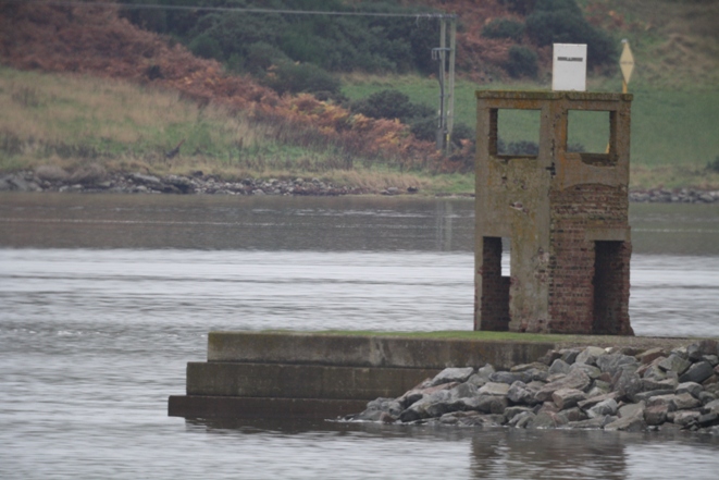
| M070 is Bona Ferry Old Light at the end of Section E
Inverness Firth Onastic lights: | ||
| M070-02 A3446 114-2916 |
Craigton Point WRG 1/4, 6m, 11/7/7 miles NH662478 |
White post about 1m on balcony of building
image Sectors shore G 085° W 064° R 048° W 312° LR26; EX416, 432; CH1078, 1078-1 On roof of building: no access |
| M070-03 A3442 114-2908 |
Avoch 2FR, 7m, 5miles NH706551 |
Concrete column about 5m
image LR27; EX432; CH1078 Access on foot along pier |
| Tower light: | ||
| M071 A3440 114-2900 |
Chanonry Oc/6, 12m, 12 miles NH750557 |
 Alan
Stevenson, 1846 Alan
Stevenson, 1846White tower 13m Alternative large image Visible 073° through N to 148° LR27; EX422, 432; CH1077, 1078 Car park close by: no access to tower or grounds |
Cromarty Firth Tower light: | ||
| M072-D A3490 114-2940 |
Cromarty discontinued 2006 (was WR Oc/10, 18m, 15/11 miles) NH787677 |
 Alan
Stevenson, 1846 Alan
Stevenson, 1846One of the only two (with M074) light-towers built as such within the old county of Cromartyshire before it was amalgamated with the county of Ross White tower 13m LR21, 27; EX432; CH1077, 1889 (no magenta flash) At roadside |
| Onastic lights: | ||
| M072-01 A3494 114-0 |
Cromarty Harbour FG, 7m, 2 miles NH785677 |
Wooden pole (not metal post as listed by Admiralty) c. 4m image alternative close-up image LR21, 27; EX432; CH1077, 1889 Car can be driven onto pier |
| M072-02 A3501 114-0 |
Alness Bay: Deephaven Causeway G 1/5, 9m, 6 miles NH638660 |
Grey metal post 7m image LR21; EX432; CH1890 Access on foot along causeway |
| M073 A3500 114-0 |
Dalmore:
Earth Embankment G 1/4, 8m, 4 miles NH666677 |
 Concrete
and brick tower 5m Concrete
and brick tower 5mLR21; EX432; CH1890 Access unclear |
| Invergordon Onastic lights: | ||
| M073-01 A3499·5 114-0 |
Queens Dock, W arm G Iso/2, 9m, 6 miles NH702683 |
Grey metal post 7m image LR21, 27; EX438; CH1889, 1889·1, 1890, In port area; no access |
| M073-02 A3499·2 114-2980 |
Supply base SW G Oc/8, 9m, 6 miles NH7068 |
no image available (impossible to pick out behind drilling platform at quayside) LR21, 27; EX438; CH1889, 1889·1, 1890 In port area; no access |
| M073-03 A3499 114-2976 |
Supply base SE G Iso/8 (not Iso/4 as listed by Admiralty), 9m, 6 miles NH708683 |
Metal lamppost 14m; lantern mounted half-way up Shown 24 hours image LR21, 27; EX438; CH1889, 1889·1, 1890 In port area; no access |
| M073-04 A3498·4 114-0 |
Admiralty Pier W side G 1/4, 5m, 3 miles NH711683 |
White metal post about 2m on dolphin image LR21, 27; EX438; CH1889, 1889·1, 1890 In port area; no access |
| M073-05 A3498·2 114-0 |
Admiralty Pier E side QG, 5m, 3 miles NH712683 |
White metal post about 2m on dolphin image LR21, 27; EX438; CH1889, 1889·1, 1890 In port area; no access |
| M073-06 A3495·4 114-0 |
Saltburn Pier W end 2FG, 5m, 2 miles NH724685 |
Grey metal post about 4m on dolphin image (taken in heavy rain!) LR21, 27; EX438; CH1889 In port area; no access |
| M073-07 A3495·2 114-0 |
Saltburn Pier E end 2FG, 5m, 2 miles NH727685 |
Grey metal post about 4m on dolphin When viewed from shore to east of pier, only one green light is visible. When viewed from the west side of the pier or from the Cromarty shore (see image), both lights are clearly visible image LR21, 27; EX438; CH1889 In port area; no access |
| Nigg Onastic lights: | ||
| M073-08 A3493·3 114-2960 |
Oil Terminal Pier W 2FG, 9m, 4 miles NH782688 |
Grey metal post on dolphin 5m image LR21, 27; EX438; CH1077, CH1889 In port area; no access |
| M073-09 A3493 114-2952 |
Oil Terminal Pier head G Oc/5, 31m, 5 miles NH783688 |
Grey square framework structure 27m image alternative close-up image LR21, 27; EX438; CH223, 1077, CH1889 In port area; no access |
| M073-10 A3493·2 114-2956 |
Oil Terminal Pier E 2FG, 9m, 4 miles NH784688 |
Grey metal post on dolphin 5m As for M073-07, only one green light is visible from certain directions. Both lights are visible from the Nigg ferry terminal image LR21, 27; EX438; CH1077, CH1889 In port area; no access |
| M073-11 A3492 114-2944 |
Ferry Jetty 2FG, 6m, 2 miles NH795686 |
Braced metal post 4m Shown only while Cromarty Ferry operates, June to October image LR21, 27; EX438; CH1077, CH1889 Access on foot along jetty during hours of operation |
Balintore Onastic lights: | ||
| M073-12 A3502 114-2982 |
Harbour R 2/12, 4m, 2 miles NH864755 |
Metal post c.2m image Visible 221° through N to 312° Publ.114 has A3503 (see next light) LR21; EX438; CH223 Access on foot |
| M073-13 A3503 114-0 |
Harbour wall G 1/5, 5m, 5 miles NH865755 |
Galvanised metal post 1m image LR21; EX438; CH115, 223 Access on foot |
Tarbat Ness Tower light: | ||
| M074 A3506 114-2984 |
Tarbat Ness 4/30, 53m, 24 miles NH947875 |
 Robert
Stevenson, 1830 Robert
Stevenson, 1830One of the only two (with M072-D) light-towers built as such within the old county of Cromartyshire before it was amalgamated with the county of Ross White tower, red bands 41m LR21; EX438; CH2, 115, 223, 2182C Access on foot from car park: no access to tower |
Portmahomack Onastic lights: | ||
| M074-01 A3508 114-2985 |
Pier head 2FR, 7m, 5 miles NH915846 |
Grey metal lamppost c.5m image LR21; EX438; CH115, 223 Access on foot |
| M074-02 A3509 114-0 |
Pontoon G 1/5, 2m, 2 miles NH915846 |
Metal post 2m image LR21; EX438 Access on foot |
Tain Onastic light: | ||
| M074-03 A3510 114-0 |
Firing range R 1/5 NH8383 |
Mast 21m Shown when firing in progress More than one mile from nearest shore no image available LR21; EX438 |
Dornoch Firth bridge The bridge has twenty piers, four of which, Nos 12 to 15 counting from the south, mark the navigation spans. They differ from the other piers in having long cutwaters at the base. The Admiralty describes three of them as "North Pier." Michael feels it better to describe them in order as "South," "South Central," "North Central," and "North." Lights are shown from small cages bracketed to the deck, one each side at each position. Fixed as they are on the outward side of the bridge railings, there is no access to any of them. The lanterns are all identical in pattern, and it is unlikely that any more images will become available. The Admiralty uses a single number for both the downstream and upstream light at each point, although they are separate lanterns. Although Dornoch Firth and the Kyle of Sutherland are navigable for small ships to Bonar Bridge, about 10 miles above the bridge, and for large boats to Rosehall, a further 10, there are no lights above the bridge. When viewed from the east, the lights are synchronised in pairs: the South Pier and the South Span; the Central and the North Spans; and the South Central and North Central piers. The North Pier goes its own way. When viewed from the west, however, there is no indication of synchronism at all; the lights present a riotous fairground aspect which adds a certain joie-de-vivre to this uncompromisingly harsh structure. Chart 223 shows a single Iso/4 light which does duty for all. Publ. 114 ignores the bridge completely. Girder-mounted lights: | ||
| M074-04 A3510·3 114-0 |
South Pier E R Iso/4, 14m, 5 miles NH7486 |
Lantern image LR21; EX438 |
| M074-05 A3510·4 114-0 |
South Span E Iso/4, 14m, 5 miles |
Lantern image similar to M074-09 LR21; EX438 |
| M074-06 A3510·5 114-0 |
South Central Pier E QY, 14m, 5 miles |
Lantern image similar to M074-08 LR21; EX438 |
| M074-07 A3510·6 114-0 |
Centre Span E Iso/4, 14m, 5 miles |
Lantern image similar to M074-09 LR21; EX438; CH223 |
| MF04-08 A3510·7 114-0 |
North Central Pier E QY, 14m, 5 miles |
Lantern image LR21; EX438 |
| M074-09 A3510·8 114-0 |
North Span E Iso/4, 14m, 5 miles |
Lantern image LR21; EX438 |
| M074-10 A3510·9 114-0 |
North Pier E G Iso/4, 14m, 5 miles NH7486 |
Lantern image LR21; EX438 |
| M074-11 A3510·9 114-0 |
North Pier W G Iso/4, 14m, 5 miles |
Lantern image similar to M074-10 LR21; EX438 |
| M074-12 A3510·8 114-0 |
North Span W Iso/4, 14m, 5 miles |
Lantern image similar to M074-09 LR21; EX438 |
| M074-13 A3510·7 114-0 |
North Central Pier W QY, 14m, 2 miles |
Lantern image similar to M074-08 LR21; EX438 |
| M074-14 A3510·6 114-0 |
Centre Span W Iso/4, 14m, 5 miles |
Lantern image similar to M074-09 LR21; EX438 |
| M074-15 A3510·5 114-0 |
South Central Pier W QY, 14m, 5 miles |
Lantern image similar to M074-08 LR21; EX438 |
| M074-16 A3510·4 114-0 |
South Span W Iso/4, 14m, 5 miles |
Lantern image similar to M074-09 LR21; EX438 |
| M074-17 A3510·3 114-0 |
South Pier W R Iso/4, 14m, 5 miles |
Lantern image similar to M074-04 LR21; EX438 |
Helmsdale Onastic lights: | ||
| M074-18 A3514·1 114-0 |
Ldg lts rear FG, 7m, 4 miles ND028152 Ldg 313° |
Pole c.10m image LR17; EX444; CH1462-F At roadside |
| M074-19 A3514 114-0 |
Ldg lts front FG, 7m, 4 miles ND028152 Ldg 313° |
Pole 8m image Shows FR at top of pole when harbour closed front and rear together LR17; EX444; CH1462-F At roadside |
Lybster Tower light: | ||
| M075 A3522 114-2988 |
South Pier head R Oc/6, 10m, 3 miles ND245348 |
 White
octagonal tower about 11m White
octagonal tower about 11mAlternative large image LR11; EX450; CH115 At car park on pier |
Clyth Ness Disused tower: | ||
| M076-D A3524 114-2996 |
Clyth Ness Discontinued March 2010 was 2/30, 45m, 14 miles ND291364 |
 White
tower, red band 13m White
tower, red band 13mNow a private house, access by invitation only LR11; EX450; CH2, 115, 1239, 2182C |
Wick plan Tower light: | ||
| M077 A3528 114-3000 |
South Pier head WRG 1/3, 12m, 12/9/9 miles ND371506 |
 White
octagonal tower 11m White
octagonal tower 11mSectors 329° R 286° W 270° G 253° LR12; EX450; CH115, 1462·1, 1954 Access on foot along pier, no access to tower |
| Onastic light: | ||
| M077-01 A3534 114-3004 |
Ldg lts front FR, 5m, ? ND369505 Ldg 234° |
Red metal post 3m image front and rear together LR12; EX450; CH1462·1 At roadside |
| Wall-mounted light: | ||
| M077-02 A3534·1 114-3008 |
Ldg lts rear FR, 8m, ? ND369505 Ldg 234° |
Red lantern on building image LR12; EX450; CH1462·1 no access |
| Disused pile structure: | ||
| M077-03 -- -- |
N Pier discontinued (in 1925 was FG, 13m) Formed rear leading light with MF07 on the South Pier ND370506 |
Six-legged pile structure 12m image alternative image LR12; EX450; shown on CH1462·1 as "Beacon" Access on foot along pier |
| Onastic lights: | ||
| M077-04 A3539·2 114-0 |
South River Pier head 2FR, 7m, 2 miles ND369507 |
Grey square metal post image LR12; EX450; CH1462·1 Access on foot along pier |
| M077-05 A3527 114-3002 |
River harbour WRG Iso/4, 9m, 10/7/7 miles ND365510 Dir 288°·5 |
Tube-light on round white metal post image Sectors 293°·5 R(3°·8) 289°·7 W(2°·5) 287°·2 G(3°·7) 283°·5 LR12; EX450; CH115, 1462·1, 1954, At roadside |
| M077-06 A3539 114-0 |
North River Pier head 2FG, 7m, 2 miles ND369508 |
Grey square metal post image MF07 in background LR12; EX450; CH1462·1 Access on foot along pier |
Noss Head Tower light: | ||
| M078 A3544 114-3012 |
Noss Head WR 1/20, 53m, 25/21 miles ND388550 |
 Alan
Stevenson, 1849 Alan
Stevenson, 1849White tower 18m Sectors S-shore W 191° R N-shore Private: access by prior telephone call only LR12; EX450; CH2, 115, 219, 1239, 1942, 1954, 2182C |
Auckengill A 4m tower was established in 1919 as the front light in a leading line about 090°. This was discontinued perhaps during World War II, when the local harbour was the home port of an anti-submarine unit. During the 1980s, the tower was observed to be vulnerable to cliff erosion and the local Historical Society decided to rebuild it further back from the cliff edge. Sadly, after it had been dismantled but before rebuilding could begin, local people used the stone pile as a quarry; and so the rebuilt tower, never intended to carry a light, is less than 2m high. It is now in its turn very close to the cliff edge. Folly tower : | ||
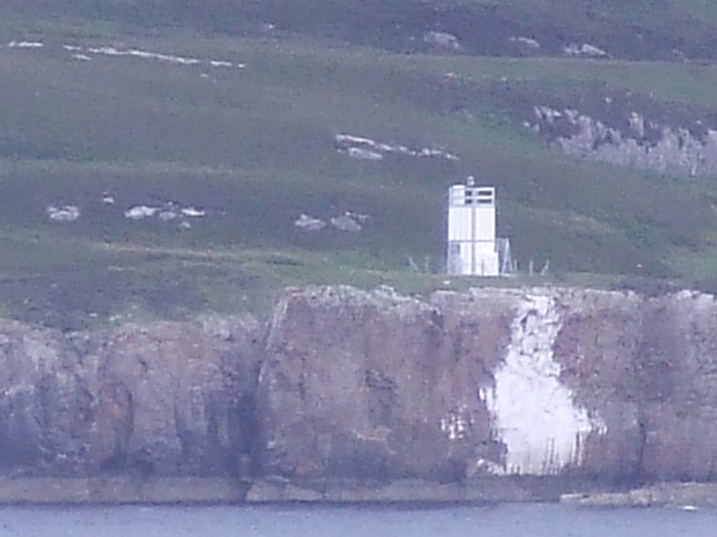
| M078-01F -- -- |
Replacing Ldg lt front discontinued (in 1925 original tower was FW, 16m, 4 miles) ND371636 |
Tower 2m image LR12; EX451; not charted Access from nearby car park |
|
Duncansby Head Tower light: | ||
|
M079 A3558 114-3016 |
Duncansby Head 1/12, 67m, 22 miles ND406734 |
 David A.
Stenson, 1924 David A.
Stenson, 1924White square tower 11m Stands on the north-easterly point of the mainland of Scotland LR12; EX451; CH2, 115, 219, 245, 1239, 1942, 1954, 2162, 2182C, 2581 Car park nearby: no access to tower |
| The Admiralty lists the lights in the Pentland Firth at
this point, here treated in Section N John O'Groats Onastic light: | ||
| M079-01 A3570 114-3036 |
Pier head R 1/3, 4m, 2 miles ND380735 |
Red metal post 3m image LR12; EX451; CH2162, 2581 Access on foot along pier |
| Stroma: Tower light: | ||
| M080 A3568 114-3032 |
Swilkie Point 2/20, 32m, 26 miles ND354792 |
 White
tower 23m. One of the three brightest lights in Scotland
(over a million candelas). White
tower 23m. One of the three brightest lights in Scotland
(over a million candelas). Swilkie Point is the north point of Stroma, on most maps called Langaton Point, though this name is properly attached to a promontory to the SW. The layout of Pub.114 is misleading in this respect: 3036 and 3040 are on the mainland LR12; CH2, 115, 219, 245, 1239, 1942, 1954, 2162, 2581 |
Dunnet Head Tower light: | ||
| M081 A3574 114-3040 |
Dunnet Head 4/30, 105m, 23 miles ND202768 |
 Robert
Stevenson, 1831 Robert
Stevenson, 1831White tower 20m Stands on the most northerly point of the mainland of Scotland LR12; EX451; CH2, 219, 245, 1239, 1954, 2162, 2182C Car park nearby: no access to tower |
Thurso Onastic lights: | ||
| M081-01 A3580 114-3052 |
Breakwater head QG, 5m, 4 miles ND122689 |
Green post c.4m image LR12; EX451; CH2162 Close to car park |
| M081-02 A3582 114-3056 |
Ldg lts front FG, 5m, 4 miles ND122688 Ldg 195° |
Grey post 3m image LR12; EX451; CH2162 Close to car park |
| M081-03 A3582·1 114-3060 |
Ldg lts rear FG, 6m, 4 miles ND122688 Ldg 195° |
Grey post 5m image LR12; EX451; CH2162Close to car park> |
Scrabster Onastic lights: | ||
| M081-04 A3583·5 114-3066 |
Fuel Quay head QR, 6m, 4 miles ND103701 |
Grey metal post 3m image LR12; EX451; CH1462-2, 2162 In port area: no access |
| M081-05 A3586 114-3072 |
Tanker Berth head 2FR, 6m, 4 miles ND102702 |
Grey metal post 3m image LR12; EX451; CH1462-2 In port area: no access |
| M081-06 A3584 114-3064 |
Ice Quay head 2FG, 6m, 4 miles ND103702 |
Grey metal post 3m image LR12; EX451; CH1462-2 In port area: no access |
| M081-07 A3583 114-3068 |
St Ola Pier head G Q2/6, 8m, 4 miles ND105701 |
Grey metal post 5m image LR12; EX451; CH1462-2, 2162 In port area: no access |
| M080-08 A3582·5 114-0 |
Queen Elizabeth Pier head 2/4, 8m, 8 miles ND106702 |
Grey metal post 4m image LR12; EX451; CH219, 1239, 146-2, 1954, 2162 In port area: no access |
| Disused tower lights: | ||
|
M082-D A3578 114-3044 |
Holborn Head discontinued 2003 (was WR 1/10, 23m, 15/11 miles) ND107706 |
 David and
Thomas Stevenson, 1862 David and
Thomas Stevenson, 1862White tower 17m Always called Holborn Head, though in fact on a southerly spur called Little Head LR12; EX451; CH1462-2, 1954, 2162 (no magenta flash) |
Strathy Point | ||
| M083-D A3590 114-3048 |
Strathy
Point discontinued 2012 (was 1/20, 45m, 26 miles) NC828697 |
 PH Hyslop, 1958 PH Hyslop, 1958White square tower on white building 14m The first major Scottish tower designed from the outset to be lit by electricity, and perhaps the last one to be built; and perhaps, after discontinuation after only 54 years, the shortest-lived LR10; EX449; CH2, 219, 245, 1954 |
| The Admiralty lists the lights in the Orkney and Shetland islands at
this point, here treated in Sections N to R Loch Eriboll Tower light: | ||
|
M084 A3874 114-3580 |
White Head WR 1/10, 19m, 13/10 miles NC458618 |
 Metal
framework tower with white cladding 5m Metal
framework tower with white cladding 5m There is room for confusion here! Loch Eriboll is a typical Scottish sea-loch, about ten miles long and generally about a mile wide, though rather broader at the mouth. The north-east corner, where the north coast is breached by the loch, is a 150-meter cliff called Whiten Head (Gaelic An Ceann Geal and so named on the map). The lighthouse, however stands about half-way up the loch, just inside the narrows, on a point known to mariners as White Head, but so much less impressive that the map gives it no name at all. Sectors 212° W 191° R 172° W S-shore LR9; EX447; CH219, 1954, 2076 |