Within this Section, Publ. 114 recognises only M026, M026-04, M028 and M029-07 Tower light: | ||
|
M026 A3102 114-2612 |
Fife Ness WR Iso/10, 12m, 21/20 miles |
 Established 1975 (PH Hyslop) on discontinuation
of North Carr Lightship Established 1975 (PH Hyslop) on discontinuation
of North Carr LightshipWhite building 5m Extraordinary building for a lighthouse: rectangular lantern room about 10 by 15 feet and maybe 9 or 10 feet high, squared-off roof overhanging the curved-on-plan full-height windows, standing directly at ground level at top of a low cliff. No doubt because of the resulting vulnerability of the glass windows to passers-by, and possibly because standing close to the windows you’d be exposed to the full power of the focused beam, this is the only lighthouse Michael has seen entirely enclosed in a chain-link fence with a strong padlock on the gate. The fence is so located on the surrounding steep ground that it is always well below the beam. At the rear of the building is a garage-like extension about ten feet square. Light source is a 100V 35A double-filament lamp. The dark phase of the Iso 10 sec period is achieved by switching a bank of resistors in parallel with the lamp to reduce the current through the filament. There is no rotating optic. During nominal off period, light maintains a very low light level, but clearly not dark—see alternative photos. This is not seen at any great distance, certainly not from S shore of Firth at distance of 12 miles, which is where you have to go if you want to see it dry-shod (except of course on the rocky foreshore a few yards to seaward). Visible only from seaward, within arc 143 to 023 True. Shows a red sector 197 to 217 True over North Carr Rocks, achieved by the insertion of a transparent strip of red plastic standing against the inside of the outer window. A subsidiary bank of prisms above the main optic ensures that the top of this strip is evenly illuminated. The Rocks are about a mile off-shore, and are also marked by an E Cardinal buoy and an unlit beacon. The beacon, and another one near Barns Ness called South Carr, mark the seaward limit of the Forth Ports Authority. Sectors shore W 217° R 197° W 143° LR59; EX371S; CH2, 175, 190, 1407, 2182B |
St Andrews Onastic lights: | ||
| M026-01 -- |
Dock entrance E side
FY, 3m Occasional: not listed by Admy NO516 1/2 156 1/2 |
Grey metal pole 2m sub-miniature lantern on top image LR59; EX371N & S |
| M026-02 -- |
Dock entrance W side
FY, 3m Occasional: not listed by Admy about 5m from M012-01 |
Grey metal pole 2m sub-miniature lantern on top image LR59; EX371N & S |
| M026-03 A3106 |
Pier head
G 1/5, 8m, 3 miles NO519166 |
Grey metal pole on lower
courses of old stone light tower 4m sub-miniature lantern on top image LR59; EX371N & S; CH190, 1407 |
| There is now no trace of two of the three lights or their structures mentioned in the 1925 Pilot and listed below. The lower courses of the pier head light still remain (see M026-03) | ||
| Pier head FRG, 6m, 6 miles ldg lts front discontinued NO5116 |
Small tower largely destroyed See M026-03 LR59; EX371N & S | |
| FW, 24m, 5 miles Ldg lts rear discontinued NO5116 |
Bracket on wall Two small partially-destroyed turrets at and close to the northern corner of the wall round the cathedral grounds have locked wooden doors and may be suggestive LR59; EX371N & S | |
| Dock entrance W side FR discontinued NO5116 |
No trace of any structure LR59; EX371N & S | |
The Admiralty lists the isolated rock tower the Bell Rock at this point, between St Andrews and Tentsmuir point; but the closest point of the mainland is Whiting Head, to the north of Arbroath, and accordingly Michael's List shows it in Section D Onastic light: | ||
| M026-04 A3129 114-2624 |
Tentsmuir Point Y 1/5 NO493282 |
Beacon no image available LR54, 59; EX371N; CH190, 1409, 1481 |
Tayport: Disused pile light: | ||
|
M026-05D -- |
Tayport pile lighthouse ldg lt front, 269° 1700 yd from rear FW, 9m, 10 miles discontinued about 1960 NO463293 |
Established 1848 (Thomas Stevenson). Circular lanternhouse
on white wooden shed, the whole supported on pile structure, overall 16m. On the same line as M028,
and acted as front element of leading lights after discontinuation of M027-D
image
The image shows M030, M031 Buddon High and Low Lights in the background LR54, 59; EX371N; CH1481 (shown as "Larick (ru)" without magenta flash) |
| There is now no trace of the following three lights mentioned in the 1925 Pilot nor of their structures | ||
| Station FR, 8m, 5 miles discontinued NO4529 |
Lantern on signal-box
Building destroyed LR54, 59; EX371N | |
| E pier head FR, 5m, 5 miles discontinued NO4529 |
White tower
Destroyed But see M026-06 LR54, 59; EX371N | |
| W pier FBlue, 8m, 4 miles discontinued NO4529 |
Post, 65m from head of pier
See M026-07 LR54, 59; EX371N | |
| Onastic lights: | ||
| M026-06 -- |
E pier head 2FR NO458292 |
Red square metal post, white bands perhaps on the site of the white tower images LR54, 59; EX371N |
| M026-07 -- |
W pier
2FG NO457 1/2 292 |
White square metal post, 65m from head of pier perhaps the same post as for the Fixed Blue light image LR54, 59; EX371N |
| Disused tower : | ||
|
M027-D -- |
Tayport Low Light FW discontinued 1848 on construction of pile lighthouse, being too close to the High Light to give a precise leading line NO451293 |
 Established 1823 Established 1823Stone tower, white lantern, 13m Also called "East Lighthouse" Tower and associated buildings now privately owned. Was front light of pair with High Light until discontinued in 1848. Five faces of the octagonal lantern are blanked off. Associated building carries plaque over front door: “Built 1823 by Trinity House, Northern Chapter, Dundee.” LR54, 59; EX371N; CH1481 (no magenta flash) |
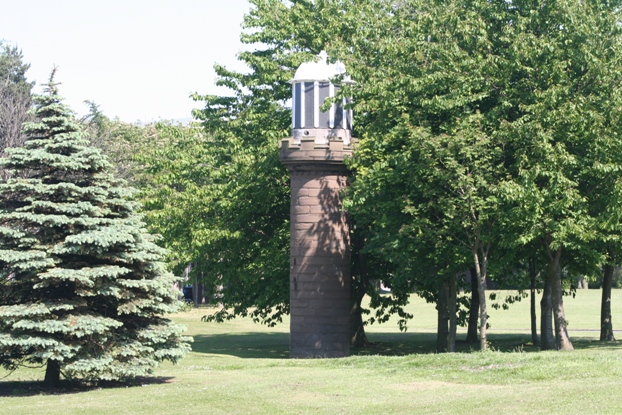
| Tower light: | ||
|
M028 A3142 114-2620 |
Tayport High Light WRG Dir Iso/3, 24m, 22/17/16 miles NO447293 Dir 269° Originally FW, 24m, 12 miles |
 Established 1820 Established 1820White tower 23m Also called "West Lighthouse" and (in Admiralty List for 1970) "Harding" Strongly directional light produced by "tube-light" (see bottom of lantern on the close-up image) Tower and buildings now privately owned. Shows WRG sector light, the whole in a cone of only 4°, visible from only one point on dry land, so that even the locals think the light is out of use. Five faces of the octagonal lantern are blanked off. Originally showed FW as rear leading light over the Low Light (later the Pile Light) as front light; tube-light installed on discontinuation of Pile Light. Line marked brings vessels into Firth of Tay. Sectors 271° R(1°) 270° W (2°) 268° G(1°) 267° For even narrower sectors see M089-04 (Section G) LR54, 59; EX371N; CH1409, 1481 |
Tay Road bridge: Onastic lights: | ||
| M028-01 A3190·1 |
S pier E side
2FR, 4m, 4 miles NO4229 |
Grey metal post 3m image LR54, 59; EX371N; CH1481-A |
| M028-02 A3189·1 |
S navigation span E side
VQ, 28m, 4 miles NO4229 |
no image available LR54, 59; EX371N; CH1481, -A |
| M028-03 A3188·1 |
Centre pier E side
2FY, 4m, 4 miles NO4229 |
Grey metal post 3m image LR54, 59; EX371N; CH1481-A |
| M028-04 A3187·1 |
N navigation span E side
VQ, 27m, 4 miles NO4229 |
no image available LR54, 59; EX371N; CH1481, -A |
| M028-05 A3186·1 |
N pier E side
2 FG, 4m, 4 miles NO4229 |
Grey metal post 3m image LR54, 59; EX371N; CH1481-A |
| M028-06 A3186 |
N pier W side
2FG, 4m, 4 miles NO4229 |
Grey metal post 3m image LR54, 59; EX371N; CH1481-A |
| M028-07 A3187 |
N navigation span W side
VQ, 27m, 4 miles NO4229 |
no image available LR54, 59; EX371N; CH1481 |
| M028-08 A3188 |
Centre pier W side
2FY, 4m, 4 miles NO4229 |
Grey metal post 3m image LR54, 59; EX371N; CH1481-A |
| M028-09 A3189 |
S navigation span W side
VQ, 28m, 4 miles NO4229 |
no image available LR54, 59; EX371N; CH1481, -A |
| M028-10 A3190 |
S pier W side
2FR, 4m, 4 miles NO4229 |
Grey metal post 3m image LR54, 59; EX371N; CH1481-A |
Newport Newport Jetty comprises two parallel slipways each about 30 feet wide, separated by a single-leaf, 7-foot masonry wall Disused onastic lights: | ||
|
M028-10A-D -- |
Ferry terminal jetty head W corner
(was) FG, 4m, 5 miles discontinued 1966 NO41842776 |
Metal post 2m on dolphin image LR59; EX371N & S |
|
M028-10B-D -- |
Ferry terminal jetty centre
ldg lt front (was) FW, 6m, 5 miles ldg 166° discontinued 1966 NO41852773 |
Large white lantern on white pole, standing on central wall image LR59; EX371N & S |
|
M028-10C-D -- |
Ferry terminal jetty root
ldg lt rear (was) FW, 9m, 5 miles ldg 166° discontinued 1966 NO41862770 |
Bracket on building image LR59; EX371N & S |
|
M028-10D-D -- |
Ferry terminal jetty head E corner
(was) FR, 4m, 5 miles discontinued 1966 NO41822774 |
Metal post 2m on dolphin image LR59; EX371N & S |
Tay Railway bridge: girder-mounted lights | ||
| M028-11 A3195·05 |
Fourth high span from south: S pier E side 2FR, 23m NO3927 |
image LR54, 59; EX371N; CH1481 |
| M028-12 A3195·15 |
Fifth high span from south: S pier E side 2FW, 23m NO3927 |
image LR54, 59; EX371N; CH1481 |
| M028-13 A3195·25 |
Fifth high span from south: N pier E side 2FW, 23m NO3927 |
image LR54, 59; EX371N; CH1481 |
| M028-14 A3195·35 |
Sixth high span from south: N pier E side 2FG, 23m NO3927 |
image LR54, 59; EX371N; CH1481 |
| M028-15 A3195·3 |
Sixth high span from south: N pier W side 2FG, 23m NO3927 |
no image available LR54, 59; EX371N; CH1481 |
| M028-16 A3195·2 |
Fifth high span from south: N pier W side 2FW, 23m NO3927 |
no image available LR54, 59; EX371N; CH1481 |
| M028-17 A3195·1 |
Fifth high span from south: S pier W side 2FW, 23m NO3927 |
no image available LR54, 59; EX371N; CH1481 |
| M028-18 A3195 |
Fourth high span from south: S pier W side 2FR, 23m NO3927 |
no image available LR54, 59; EX371N; CH1481 |
River Tay S bank: Onastic lights | ||
| M028-19 A3196·5 |
Ballinbreich R 1/3, 3m, 2 miles NO266205 |
Green metal pole 2m no image available LR53, 59; EX370, 380W; CH1481-B |
| M028-20 A3197 |
Castle R 2/5, 3m, 2 miles NO261199 |
Red metal pole, grey railed
platform 3m image LR59; EX370, 380W; CH1481-B |
| M028-21 A3198 |
Jock's Hole QR, 8m, 2 miles NO257196 |
Grey metal post 7m, protected ladder, no platform
images LR59; EX370, 380W; CH1481-B |
| M028-22 A3198·2 |
California R 2/5, 3m, 2 miles NO252193 |
Red metal post, grey railed platform;
miniature lantern on top of solar panel unit, on short metal pole fixed to railing;
square topmark images LR59; EX370, 380W; CH1481-B |
| M028-23 A3198·5 |
Newburgh Head R 1/3, 3m, 2 miles NO242190 |
Red metal post, grey railed platform;
miniature lantern on short metal pole fixed to railing; separate solar panels;
square topmark. Also TV and other aerials
image LR59; EX370; CH1481-B |
| M028-24 A3199 |
Linoleum Slipway R 2/5, 3m, 2 miles NO231186 |
Red metal post, grey railed platform;
miniature lantern on short metal pole fixed to railing; separate solar panels;
square topmark. image LR58; EX370; CH1481-B |
| M028-25 A3200 |
The Peat QR, 3m, 2 miles NO |
Red metal pole 2m no image available LR58; EX370; CH1481-B |
| M028-26 A3200·1 |
Carpow R 2/5, 3m, 2 miles NO |
Red metal post with grey railed platform image LR58; EX370; CH1481-B |
River Tay S bank (continued): Onastic lights this header introduced for indexing purposes | ||
| M028-27 A3202·3 |
Cable Warning SE Y 1/5, 9m, 3 miles NO |
Mast 7m no image available LR58; EX370; CH1481-B |
| M028-27A A3202·3 |
Cable Warning SW Y 1/5, 9m, 3 miles NO |
Mast 7m no image available LR58; EX370 |
| M028-28 A3200·15 |
Girnal R 1/3, 3m, 2 miles NO197189 |
Red metal post with grey railed platform image LR58; EX370; CH1481-B |
| M028-29 A3202·4 |
Mare's Head R 2/5, 3m, 2 miles NO185196 |
Red metal post with grey railed platform image LR58; EX370, 380W; CH1481-B |
The reference M028-30 is not used. Michael had the Inchyra light on the wrong side of the river!--now M028-52A | ||
| M028-31 A3203·2 |
Seggieden S R Iso/4, 4m, 4 miles NO168211 |
Wooden pole with small red band and red reflective
panels; lantern on top 8m (see also M028-49) images LR53, 58; EX369, 370, 380W; CH1481-B |
| M028-32 A3203·6 |
Carfud R 1/3, 3m, 2 miles NO155215 |
Red metal post with grey railed platform no image available LR53, 58; EX369, 380W; CH1481-B |
| M028-33 A3204 |
Sleepless Inch NE R 2/5, 4m, 2 miles NO149221 |
Column no image available LR53, 58; EX369, 380W; CH1481-B |
| M028-34 A3204·4 |
Sleepless Inch NW R 1/3, 4m, 2 miles NO145221 |
Aluminium pole, red bands 4m image LR53, 58; EX369, 380W; CH1481-B |
| M028-35 A3204·6 |
Orchard Nook R 2/5, 3m, 2 miles NO138217 |
Red metal post with grey railed platform image LR53, 58; EX369, 380W; CH1481-B |
Friarton bridge: The Friarton Bridge carries the M90 motorway across the river. Each vertical pair of fixed reds and greens on the piers nearest the river, showing upstream and down, are about 20m apart, too far to be fully shown in a single image. They are therefore given individual M-numbers. The arrangement of the long bolts supporting lamps hanging from the underside of the deck is best seen at M028-43 Girder-mounted lights: | ||
| M028-36 A3205 |
S pier lower E side FR NO130216 |
Bracket bolted to pier Approached by short ladder separately bolted to pier image LR53, 58; EX369 |
| M028-37 A3205 |
S pier upper E side FR NO130216 |
R lantern on plate hanging by long bolts
from underside of deck no image available LR53, 58; EX369 |
| M028-38 A3205·2 |
Navigation span, centre E side FW NO131216 |
W lantern on plate hanging by long bolts
from underside of deck no image available LR53, 58; EX369, 380W |
| M028-39 A3202·4 |
N pier lower E side FG NO132217 |
Bracket bolted to pier Approached by short ladder separately bolted to pier image LR53, 58; EX369, 380W |
| M028-40 A3202·4 |
N pier upper E side FG NO132217 |
G lantern on plate hanging by long bolts
from underside of deck no image available LR53, 58; EX369, 380W |
| M028-41 A3203·4 |
N pier upper W side FG NO132217 |
G lantern on plate hanging by long bolts
from underside of deck image LR53, 58; EX369, 380W |
| M028-42 A3203·4 |
N pier lower W side FG NO132217 |
Bracket bolted to pier Approached by short ladder separately bolted to pier images LR53, 58; EX369, 380W |
| M028-43 A3204·2 |
Navigation span, centre W side FW NO131216 |
W lantern on plate hanging by long bolts
from underside of deck images LR53, 58; EX369, 380W |
| M028-44 A3204 |
S pier upper W side FR NO130216 |
R lantern on plate hanging by long bolts
from underside of deck image LR53, 58; EX369 |
| M028-45 A3204 |
S pier lower W side FR NO130216 |
Bracket bolted to pier Approached by short ladder separately bolted to pier image LR53, 58; EX369 |
|
River Tay: S and N sides: Onastic lights | ||
| M028-46 A3207·2 |
Friarton Road outfall R 1/3 NO119217 |
Metal post of varying diameters: lower
part white with black bands, central part red, upper part red with white bands. Seems to have suffered collision damage image (shows M028-47 in background) LR53, 58; EX369; CH1481-B |
| M028-47 A3207 |
Moncrieffe island G 1/3, 3m, 2 miles NO120216 |
Green metal post, white top;
white railed platform; lantern mounted on short metal post fixed to railings 3m image LR53, 58; EX369; CH1481-B |
|
(northern end of Friarton Bridge) River Tay: S and N sides: Onastic lights | ||
| M028-48 A3204·7 |
Stock Green G 2/5, 5m, 2 miles NO136218 |
aluminium pole 4m image LR53, 58; EX369, 380W; CH1481-B |
| M028-49 A3204·5 |
Bowes G 1/3, 3m, 2 miles NO147223 |
Green metal post with white platform no image available LR53, 58; EX369, 380W; CH1481-B |
| M028-50 |
Seggieden gaspipe N 2FY NO168214 |
post with white diamond image LR53, 58; EX369, 370, 380W |
| M028-51 A3203 |
Seggieden oilpipe N G Iso/4, 4m, 4 miles NO168214 |
wooden pole with orange bands and reflective panels 8m image LR53, 58; EX369, 370, 380W; CH1481-B |
| M028-52 A3202·8 |
Ribny G 2/5, 3m, 2 miles NO171222 |
Green metal post with white railed platform image LR53, 58; EX369, 370, 380W; CH1481-B | M028-52A A3202·5 |
Inchyra WR Long/6, 3m, 7/5 miles NO181204 |
Red metal post with grey railed platform 3m flash 2 sec image Sectors shore W 087° R 022° W shore LR53, 58; EX370, 380W; CH1481-B |
|
River Tay N bank (continued): Onastic lights this header introduced for indexing purposes | ||
| M028-53 A3202·25 |
Cable warning NW QY, 7m, 3 miles NO198190 |
wooden pole with yellow diamond 7m image LR58; EX370, 380W; CH1481-B |
| M028-54 A3202·2 |
Cable Warning NE QY, 7m, 3m miles NO199190 |
wooden pole with yellow diamond 7m image LR58; EX370, 380W; CH1481-B |
| M028-55 A3200·05 |
Wonder G 1/3, 3m, 2 miles NO |
green metal post with white railed platform 3m image LR58; EX370; CH1481-B |
| M028-56 A3199·5 |
Reckit Lady G 2/5, 3m, 2 miles NO229188 |
Green metal post, white railed platform;
miniature lantern on short metal post fixed to railing. Separate solar panels;
triangular topmark. 3m image LR58; EX370; CH1481-B |
| M028-57 A3198·1 |
Bell's Bank G 1/3, 3m, 2 miles NO251194 |
Green metal post, white railed platform;
miniature lantern on top of solar panel unit on short metal post fixed to railing.
Triangular topmark. 3m image LR59; EX370, 380W; CH1481-B |
| M028-58 A3196 |
Deil Bank G 2/5, 3m, 2 miles NO282215 |
Green metal post, white railed platform no image available LR53, 59; EX370, 380W; CH1481-B |
(northern end of Tay Railway Bridge Dundee In 1930 there were 13 lights on the Dundee waterfront, all of which except for the next four have been destroyed Two of these were towers at Camperdown Dock. Disused tower: | ||
|
M029-D -- |
Dundee Middle Pier (in 1930) FR, 7m, 5 miles discontinued NO405300 |
 Established 1827.
Masonry tower
6m.
Originally stood on wharf of William IV Dock, as the rear element of
leading lights leading clear of the Beacon Rock. Now stands in municipal
parkland 100 yards from present sea wall Established 1827.
Masonry tower
6m.
Originally stood on wharf of William IV Dock, as the rear element of
leading lights leading clear of the Beacon Rock. Now stands in municipal
parkland 100 yards from present sea wall LR54, 59; CH1481-A |
(northern end of Tay Road Bridge) Onastic lights: | ||
| M029-01 --- |
Beacon Rock Fl R, 5m, 5 miles discontinued NO412300 |
Post on concrete base on drying rock no image available LR54; CH1481; CH1481-A |
| M029-02 A3170 |
Dundee Tidal basin W 2FR, 6m, 4 miles NO425307 |
post 4m images LR54; CH1481; CH1481-A |
| M029-03 A3168 |
Dundee Tidal basin E 2FG, 6m, 4 miles NO426307 |
post 4m images LR54; CH1481; CH1481-A |
Broughty Ferry Onastic lights: | ||
| M029-04 A3135 |
Broughty Ferry Lifeboat pier 2FR NO460306 |
Post image LR54; CH1481 |
| M029-05 A3134 |
Broughty Castle 2FG, 10m, 4 miles NO465303 |
Red metal post 3m image LR54; CH1481 |
Monifieth and Barry Range The Barry Range is a designated military training ground, and firing with live ammunition takes place regularly. At such times red flags are flown at points where access may be obtained, and the red light M029-06 is shown. The structures M029-06, M029-07, M030 and M031 are all within the boundaries of the range, and access to them is often dangerous Onastic lights: | ||
| M029-06 -- -- |
Barry Range West QR, ?, ? NO505322 |
Grey post 4m. Not listed by Admiralty. Occasional:
shown when firing is taking place on the Barry Range image LR54 |
| M029-07 A3129·5 114-2628 |
Monifieth Y 1/5 NO507322 |
Directional light marking gas pipe image LR54; CH190, 1481 |
Buddon Ness: Disused towers: The sandbanks in the mouth of the Tay are notorious for their variability of position. The two Buddon Ness lights were designed to give a leading light through the banks both inward and outward, and the front tower was the first to be designed to be easily movable, to follow the movements of the channel. D. Alan Stevenson, in The World's Lighthouses to 1820, suggests they may have been first erected in 1600, but this would make them antecedent to the coal light on the Isle of May. Other sources suggest dates between 1660 and 1687, making them the second lighthouses in Scotland. It was seventy years before another Scottish light was established. The towers were originally built of wood, and probably lit by candles mounted inside a lanternhouse. The rear tower was rebuilt in stone in 1753, perhaps retaining the candle lantern, to a height of 17m. In 1789 both towers were converted to oil lamps with reflectors by Thomas Smith, working on behalf of the Dundee Trinity House, not the Northern Commissioners. Thomas Stevenson rebuilt both towers in stone, into the design seen today, in about 1880. They were discontinued in 1943 because the alterations of the channels could no longer be marked by moving the towers. | ||
| M030-D -- |
Buddon Ness (Old High Light)
FW, 31m, 16 miles Inward ldg lt, rear 296° discontinued 1943 NO539310 |
 White
tower 32m White
tower 32m400 yards from front light (and see M026-05) LR54; EX382S; CH190, 1407, 1409, 1481 (no magenta flash) |
| M030-Da -- |
Buddon Ness (Old High Light)
FW, 30m Outward ldg lt discontinued 1943 Same structure as M030 |
White tower 32m
When seen over Broughty Castle led N of Newcombe Shoal off Tayport no image available LR54; EX382S; CH190, 1481 (no magenta flash) |
| M031-D -- |
Buddon Ness (Old Low Light)
discontinued 1943 FW, 19m, 13 miles NO542308 |
White tower 20m images see M030-D and M026-05 LR54; EX382S; CH190, 1481 (no magenta flash) |